]]>
The Center of the Path traverses from Oregon to Florida. I chose to go to Jackson Hole where the center of the Path crosses just north of Jackson Hole in the Grand Teton National Park. The weather is dry here with better chance of cloudless skies and plenty of beautiful nature to boost. The worse scenario is to be in position and a cloud obscure the sun and all is lost.
The parks and town were expecting extremely high volume of visitors on that day. The day of the eclipse I drove down from Yellowstone 4 am in the morning to be in position at Grand Teton National Park by 6:30 am. I was lucky to get into the the Glacier View Lookout Point. Grand Teton Mountain is right there to the West. The eclipse starts around 10:15 am. We have the telecom lens ready to capture the entire sequence. Another wide angle lens to take time lapse photos. Totality hit 11:36 am and lasted 2 min 19 secs on the center of the Path. I chose to be about a couple of miles north of that to avoid the huge traffic in the designated area on Gros Venture Road. That lost about 3 secs of the totality. The Eclipse will be finished by 1 pm.
When the time reached 10:15 am, the moon started to cover the sun and took a bite out of it. And a light shadow gradually moved over us. The light around us gradually dimmed until it approached totality. Up to this point the eclipse is about the same as what I saw last time in Bryce Canyon. Last time during totality of the Annular Eclipse a ring of fire remains and the sun is still too bright. Some light still reached us from the rims of the sun. You can find some pictures of that in the Skywatching section of the photo site. But this time totality is different.
And then the magic moment came. It became very dark. The horizon shows a red glow like the twilight. Temperature dropped. It was hot when the sun was shining high but suddenly in the shadow it was cold like the pre-dawn hours. I judge about 10 to 20 degree F drop in that 2 minute 15 sec totality. People are wo-hooing around us. We hurry to remove the solar filters from the camera. I tried to take video and pictures of people. I wished I had more arms. I looked up at the sun and see with naked eye the dark sun with the corona around it. I looked through the camera viewfinder and saw the sun flares in red and purple and orange and the white corona radiates out from the rim. They are flashing and spitting fire into space. I looked up and saw the dark sun and a star next to it which I think is Venus. The mountains are all dark. The horizon are still alight in a red glow. The two minutes 15 sec lasted way too short to look around, look up, take pictures, and take video all at the same time. Then suddenly it is over, I saw the flash of light as the sun emerges from behind the moon. That's the Diamond Ring Effect see the picture here. It lasted may be a sec at most. Then the light returned quickly. I could feel the heat came back like a heater getting turned on.
The rest of the eclipse mirrorred the first half. Some people rushed to leave the site. We of course stayed until the end. By that time, about half the people were gone from our pullout point. I can see a long line of cars in the far away Grow Venture Road waiting to get back to the highway. We left around 1:30 pm and drove all the way back to Salt Lake City Airport. The first 3 hours are through heavy traffic on one lane road just to get out of the Eclipse area.
We saw a car on the highway with dusty windows and these words fingered on the rear glass. "Totality or Bust", "It was so good! :-)" . That just about sums it all up. It was incredible. Truly an unforgettable experience.
]]>I am lucky to get a pass to enter the enclosed area and photo the parade up close. Not having to get squeezed by the crowd is great. And I get to see the exciting faces of the people enjoying the festivity.
]]>I started the next day exploring the Killington Resort. There is a small lake and it is beautiful around it. Morning light is best when capture the varying colors of the leaves. Heading South along Route 100 I passed by some small lakes. Echo lake is rather nice with a boat ramp. I stopped in Okemo Ski Resort. The hill is not as high but I hiked up a short trail to get up close to the maple trees. Then I drove East and then North to Woodstock. This is an old town which library and town hall and church at the center of town had typical period architecture. Further east is Quechee Gorge. The route passed over the top on a bridge and the view is nice. I took Route 4 West back to Killington. I ended the day early enough to see the sun setting just behind the hills casting shadows on the far away hills. The glow of the sun turns the hill top into fiery reds.
East of the Green Mountain is Route 7. I drove East to Rutland. But I forgot that I really wanted to try Route 73 or Route 125. So after reaching Brandon, I turned East onto Route 73 and crossed the mountain to Rochester. Take Route 100 North again to Hancock. Turn West onto Route 125 crossed the mountain again to get to Middlebury. This long route took me through the mountain and is really beautiful and awesome.
I continued North on Route 7 from Middlebury to Burlington. From the waterfront I can see Lake Champlain. It was raining so there is not much to see. A lot of shops are closed after summer season. If the weather was nice, I could take a lake cruise. But I stayed in town and walked the pedestrian cobblestone streets. To see more of Lake Champlain I went north to Sand Bar State Park. It connects the Grand Isle, which is an island in Lake Champlain. From here it is not far from the Canadian border. I went as far as the Grand Isle State Park. This is a very small park. The sun came out briefly for me to take some pictures. Then I went back to Burlington and took the highway I-89 South back to Killington.
Last day of the trip I feel like I don't have enough of the famous Route 100 so instead of just going south back home I headed North again on Route 100. After Reaching Rochester I took Route 73 West to Brandon and then turn South onto Route 7 and drove all the way along the length of Green Mountain to exit Vermont out of the southern state border. The remaining route was simply heading towards Albany back onto highway I-87 and home.
All in all we drove more than 1,000 miles on this trip. I can say I saw the peak fall foliage in Vermont and it is unforgettable.
]]>
]]>
On this trip I stumbled on a few interesting water reflections. I tried to capture the impressionistic nature of the water movement.

We found a good spot on the harbor walk. There are a series of benches right next to our parking spot which is perfect. There are sailboats and water reflections. We set up 3 tripods and mounted 3 cameras each with difference lenses. A telephoto for the close up, a wide angle for the stacked sequence and another medium zoom for people images. We were all set by 8 pm. We started photographing the super moon. We set the timer for time lapse and started shooting around 9 pm. Full eclipse started 10:11 pm which is when you can see the blood moon. Total eclipse maxed out at 10:47pm and began exiting the shadow by 11:23pm. Partial eclipse ended by 12:27am.
The temperature was cool around 60's. There was a bar behind us blasting some music. The walkway was quiet but occasionally some locals or tourists passed by. Some sat down on the bench and watched with us. Some were curious enough to stop and took a peek at our cameras. It was a great night.
We returned home on empty highway. I have never seen BQE or I-95 so empty before. After some sleep and a full work day, I stacked the photos and was very happy with the result.
It was my 4th lunar eclipse viewing and the best. My first attempt at photographing lunar eclipse was from the days of film camera. The second try was on a very cold and windy winter night. Due to the strong wind causing camera shake I did not get many good shots. I did not have a timer then. The previous eclipse was very cloudy and the moon was only visible a few times. So this is the first real success. I bet the clear air outside of the metro area helps too. It is well worth the long drive. Like someone said, "I go the extra mile to get this!"
]]>]]>
Slept late to 11 am. Ate a large breakfast. Walked around the cruise ship in the afternoon.
At the end of the sailing season, the gift shop put out lots of tee shirts and souvenirs for sale.
We went to pick out the photos from the portrait night.
Lobster dinner
There are enough passengers who don't eat shellfish so there are extra available. The waiter is very nice to gave us extra servings.
Unforgettable Sunset
The sunset was gorgeous. The twilight was reddish purple on the horizon.
| Back to Day 11-Athens, Greece | Day 12-At Sea | Next to Day 13/14-Venice, Italy |
]]>
We were a bit disappointed when we went to the open deck and looked out to lots of fog. As we approached Venice the fog started to lift. The sun was coming up higher and the beautiful city of Venice emerged from the fog. Well, that added a bit of mystery to Venice. We took the ferry to St. Mark’s Square.
St. Mark's Square (Piazza San Marco)
First we looked around St. Mark's Square. First thing we saw was the Doge's Palace. Many delicately carved columns and arches adorned the front of the Palace. Each column had different carvings on top. We will be visiting the palace tomorrow. So more on that later. Next to the palace is the St. Mark's Basilica (Basilica of San Marco). The church is richly decorated with marble and mosaics. The four bronze horses was set on top of the main entrance. Next to the Basilica is the Clock Tower with the twelve zodiac signs. Across is the Bell Tower (Campanile). The square is large and is rectangular in shape. There are some cafes and shops around the square.
Rialto Bridge
From St. Mark's Square we walked through narrow streets to the Rialto Bridge. Along the way we saw small canals and gondolas in the waterway. There are many souvenir shops from here to Rialto Bridge. These shops sell Murano glass accessories, venetian masks, and other common souvenirs. The Rialto Bridge is a tall white bridge over the Grand Canal. The Rialto Bridge is big enough to have shops over the bridge. Under the bridge there are gondolas for hire. We did not do the gondola rides. After crossing the bridge was the S. Giacomo which had an interesting clock. We turned back and spent some time browsing the souvenir shops.
Overnight at Venice
We went back to the cruise ship for dinner and came back out to the square at night for a couple of hours. At night the square was all lit up and was very beautiful. We took night photos of the square. I took a picture with the moon rising directly behind the cross on top of the church as if the cross was glowing which was awesome.
We returned to the cruise ship for the last night on the cruise. The next day we disembarked the cruise ship in the morning. We took our luggages to a hotel 5 min from St. Mark’s Square. Very small room and very small bed. Furnitures are antique look alike. The metal room key has a large tassel on it.
St. Mark's Basilica (Basilica San Marco)
Inside the St. Mark's Basilica I only remembered very intricate marble mosaic on the floor. There were gilded wall paintings of the saints. Inside I went to the back where I saw exhibits of the history and artifacts from the church. The four bronze horses outside are replica. The original bronze horses were moved inside and can be viewed here. We went up to the balcony that overlooks the St. Mark's Square.
Doge's Palace (Palazzo Ducale)
A fine palace with lots of painting, ceiling fresco, marble statues. The many decorated rooms with fine carved furniture. Some rooms are where the royalties met to discuss state affairs. Huge paintings of royal weddings and coronations, and war victories adorned the walls. There were some royal jewelry on display. The prison area next to the court is a stark contrast to the opulent palace.
We did not go to Murano Island to see the glass factories. I was afraid I would buy some expensive but useless glass stuff which I had to hand carry home.
For the remainder of the day we roamed around town through the many narrow streets and browsed the many souvenir shops.
Tasty pizza, tiramisu and cappuccino concluded our wonderful trip and then we returned home the next day.
| Back to Day 12-At Sea | Day 13/14-Venice, Italy | Go to National Parks Travelog |
]]>
Endless ride after rides. So much fun.
Disney World
Magical Kingdom
Epcot Center
Hollywood Studio
Animal Kingdom
Sea World
Universal Themed Park
Universal Studio
Universal Island of Adventures
]]>This was another DIY tour and we started very early. We left port Pireus around 8am and took a free shuttle to Port Terminal Main building. Then we walked to the metro station. Took metro green line to Omonia station, transfer to Red line towards Dimitrio, 3 stops to Acropolis. We got there before 9am and we arrived sooner than the rest of the cruise guests. So we got a little head start on taking photos before the crowd arrived.
Acropolis
After we got out of the subway, we walked up a trail towards the Acropolis. First, we walked by Dionysis Theater. This is a large semi-circular theater built along the hill. Further up is the Parthenon. This is likely the highest point in the city. From here I looked down over the city of Athens below us. The temple was mostly broken and defaced. The actual pieces were moved to the museum. Most of what can be seen here are replicas. One side was under maintenance with scaffolding around it. It was a very nice day with clear blue sky. We walked around the Acropolis once to admire it in all angles. It is really big. Standing under the columns gave me a sense of scale of how big this temple really is.
Erechtheion
A short distance away is the Erechtheion. One side of the roof was supported by 6 maiden statues, called Caryatids, as columns. Again the statues were removed to the Museum and replaced with replica here. They are simply lovely. I could imagine how gorgeous they once were.
Acropolis Archaeological Museum
Next to the Acropolis is the Museum. Admission was only 1 Euro. Near the entrance there was an area with glass floors. Through the glass floor I could see archeological sites underneath it. Inside they do not allow photography. We saw a lot of the artifacts from the Acropolis displayed here. We also saw a film about the history of the Acropolis on how it was built, destroyed by war, and earthquake. We also saw the maiden statues I mentioned before. For information about the museum and exhibit http://www.theacropolismuseum.gr/en
Symtagma Square
After leaving the Acropolis we went back down hill into the city. Following the map we walked to Symtagma Square to watch the change of guards. The change of guards is at noon. When we got there, there were already a small crowd of tourists. The change had just started a little. The change of guard did not take long and was over soon. The Tombs of Unknown Soldiers is also here.
Plaka shopping district
A short walk from the Symtagma Square is the Plaka shopping district. This area is just some small narrow cobbled stone streets with lots of souvenir shops. May be we were there early and the crowd hasn't arrived yet. The streets were rather quiet. We browsed around for souvenir and bought a little mini vase with Greek painting on it.
Arch of Hadrian and the Temple of Zeus
Leaving the Plaka district we went to the Temple of Zeus. We could see it as soon as we moved out to the open away from the buildings. This site was entered through the Arch of Hadrian. There are inscriptions on the arch. The arch marked the separation of the old and new ancient city. From a distance I was already amazed by the size of those columns in the middle of the site. But when I got closer to the temple of Zeus I realized how giant those columns really were. They are even bigger than those at Parthenon. I could imagine how grand it once was before it collapsed. There were still a bunch of columns standing. A fallen columns broke off in segments like a stack of fallen cookies. I wished there were more structures or artifacts left behind. But only the few columns remained for us to imagine what it might have looked like back in ancient times.
Return to Acropolis metro station and return to port at Pireus.
We returned the same way we came. Took the subway from Acropolis metro station and returned to port. Then took a bus #843 to the Terminal entrance instead of walking the 20 min. It was still early but I already finished my itinerary so we return to the ship for dinner.
Saving tips:
Get the subway train day pass for 3 Euro and Museum cost 1 Euro. Great value.
| Back to Day 10-Kusadasi, Turkey | Day 11-Athens, Greece | Next to Day 12-At Sea |
]]>
The House of Virgin Mary
After getting off the bus, we were led through a path up a hillside to the last home of St. Mary. Outside the front there was a sign that told the story of how the house was found. There was also a statue of St. Mary before you reached the house. It is a small stone house. The house consists of a small living area, a hearth and a small bedroom. The extremely long line of tourists threaded through the house so we were quickly moved through and out the other side of the house. Outside the house there were some glass covered stands for candle offerings. Along a wall outside the house pilgrims placed wishing notes on white ribbons on the wall. We were lucky to have arrived early. By the time we exited the house the line of tourists was stretching out a long long way down the path back to the entrance.
Ephesus
Ephesus must have once been a vibrant town back in ancient times.
Odeion - After passing through some scattered ruins, we reached a small theater Odeion.
Temple of Domitian - One prominent feature was a double columns topped with two statues.
Prytaneion - Beautiful carving of the Winged Nike Goddess of Victory.
Curetes Street - A main road lined with columns.
Trajan Fountain - Sculpted columns was reconstructed to show what it might have looked like but much smaller with shorter column sections.
The floor was tiled in very intricate mosaic patterns as colorful as a carpet. The patterns were quite varied. It almost seemed like the artists were trying to showcase a variety of patterns.
Temple of Hadrian - four columns with Corinthian capitals supports a triangular pediment. Above the two columns in the middle, there is an arch which curves down from the pediment, and the bust of Tyche, the goddess of the city, which adorns the center of the arch. On the second semi-circular frontal over the door, the figure of a maiden resembling Medusa is depicted among flowers and acanthus leaves.
Latriana - public toilets of Ephesus.
Ephesus Library of Celsus- the façade is two stories high decorated elaborate carvings. The columns are arranged in pairs and between them there are three doors with richly decorated frames. There were four statues in the alcoves. The back of the facade was reenforced with reconstructed stones. There were inscriptions on two large plaques about the site.
Ephesus Theatre - The theatre was consisted of three main sections, the stage building, the orchestra and the auditorium. This was supposed to be where St. Paul or St. John had preached. This theater was rather big and was built along a hillside. The lower tiers were reconstructed. We walked down to the center, around the benches and looked through some passageways. But the upper tiers were fenced off. It could be seen that the loose stones in the fenced off area were rather crumbled up. The center area was flat and was already repaved with new stone flags. Many columns remained at the stage building section.
Harbour Street - There was another column lined path out the other side of the amphitheater. Off the side of the path there were some sarcophagus laid out in a roped off area. This looked like a burial ground.
Basilica of St. John
This church was built over St. John’s burial ground. There is an large gateway under what looks quite like fortress walls. Inside the most we saw were columns, archways and sections of the walls. There was a sign that outlined the layout of the church. Near the center we found the tomb of St. John marked by four columns and a stone plague. Some of the columns were carved with a spiral pattern and topped with an inscription of a sign that seems to be combination of letters and symbols. From here looking up a hill I could see a fortress in a distance. I don't know what that was and our tour did not go there.
After a bus ride back we stopped at the port Kusadasi and walked back to the cruise ship.
Read more about Ephesus here. http://www.kusadasi.biz/
| Back to Day 9-Istanbul, Turkey | Day 10-Ephesus, Turkey | Next to Day 11-Athens, Greece |
]]>
I feel less comfortable in taking public transportation in Turkey due to language barrier and lack of information. So I paid $12 per person for the cruise ship shuttle bus to take us directly to the Grand Bazaar entrance. We walked around inside the market until 9:30am. This is like a very large stone walled area with multiple entrances and exits. There are lots of shops. Most of them sell souvenirs. There are colorful glass lamps, hand painted ceramic plates and bowls, woven carpets and throws, silverware, figurines made from wood or marble, wooden boxes with mother of pearl inlays. Before we left the market, we bought some turkish delight sweets to bring home. The sweets are little squares of fruit flavored gummy like candies. Some of them has nuts. Each one is dusted in fine powdery sugar. Inside the market we run into Jolene and Song again. We had to pay to use the restroom. There are people in the stores that offer you some kind of tea. We are on the cautious side and did not try any because we are traveling alone.
Aya Sofia (Hagia Sofia)
From the Grand Bazaar we followed the map and walked to Aya Sofia. It is now a museum but it was a church and was later converted to a mosque. It has a very high dome. There are many glass stained windows. Sunlight came in through the many windows high up around the dome. The interior is very dark. The first thing you see are several large round plagues with writings hung up on the pillars. Some of the walls are painted with saints and some of them are gilded. The walls and floors are tiled with marble. The top of the pillars has intricate carvings. We went up to the second floor gallery. From one side you can look out to the city. Looking down it is amazing how big the place is. When the church was converted to a mosque certain religious paintings and mosaics were plastered over. Some of them have been restored or partially uncovered. The islamic features of minarets were added later.
Blue Mosque
Then we went to Blue Mosque-Suttanahmet. It is closed at 12 noon for prayer. So we left but we will come back later. As we got out we saw Jolene and Song again.
Underground Cistern, The Basilica Cistern
Next stop is the Basilica Cistern which is an underground water cistern (10 T.R. pp). It is said that the place was built to store water in the ancient city. The underground cistern has many stone columns dimly lit with up lights. It is cool and dark inside. There are fish in the water. The place is a bit creepy with the columns standing in water and ghostly lit with orange yellow lights. Voices echo inside the cavernous space. We walked along the walkway looking for the Madusa head statue and found it lying sideways at the far end of the Cistern at the base of a column. Not far from the Madusa head is a column with carvings that looks like water. It was difficult to take pictures in the low light. When we are done we came back out and went to Topkapi Palce (20 T.R. pp).
Topkapi Palace
Topkapi Palace is very beautiful. There are several large courtyards, lots of smaller buildings in several areas separated by gateways with walls covered with colorful tiles and frescos, gilded decorations. There is an imperial council chamber that has gilded gates on the entrances. Inside are benches around the walls. The walls and ceilings are all painted and tiled. Every bit of surface is covered with decorations. Some rooms do not allow photography. In Sultan's bedroom I saw a spread embroidered with pearls and precious stones, studded with gold, emeralds and rubies. Amazing treasures like Sultan’s clothes, jewelry, giant emerald, diamonds and ruby, huge gems in the treasure room. There are lots of jewels studded swords, armors, head pieces, cups, medallions, jewelry of all kinds in treasure boxes. Among the various buildings in the palace there are fountains, pavilions, gardens. The gardens are rather simple and less decorated than the interiors. Many of the walls are highly decorated. Some are tiled, or painted. Some of the doors, specifically cabinet doors are inlaid with intricate mother of pearl patterns which gave it a wonderful shimmer from the dim light through the windows.
Back to Blue Mosque
Headed back to Blue Mosque. I did not remember whether we ate or what we ate. I only remember getting a freshly squeezed pomegranate juice from the street vendor. When we arrived at the Blue Mosque the midday prayer was just over. There was a short line at the entrance. By the time we got to the door in a few minutes, there was already a long long line behind us. We need to take off our shoes before going in. It is free to enter. At the entrance someone handed out bags to visitors to hold their shoes. The place is very large. The main building is surrounded by a large court yard. Each corner of the walled area has a minaret. The building center is a huge dome like Aya Sofia. It was also dim inside. The center of the mosque which is the prayer area is roped off and is lined with carpet. The ceilings and walls are tiled or painted in intricate patterns. Unlike Aya Sofia the colors here is lighter and brighter. In comparison Aya Sofia looks much older than Blue Mosque.
Back to Grand Bazaar
The meeting point for the shuttle bus is outside the Grand Bazaar. When we got there we did some final looking around for souvenir. Then we headed back outside to the shuttle bus pick up location. Like I said in the beginning there are multiple exits. The place is really big and the stores look alike. We got the wrong exit a couple of times and were making circles inside. Finally we found the correct exit to get back to the waiting location. The bus took us back to port and the cruise ship. Along the way we saw from the bus window the large bridge that connects the Europe and Asia continent. The sun was about to set. As we sailed out of port, the setting sun passed behind both the Blue Mosque and Aya Sofia. I took pictures with the sun directly over their top. I stayed on top of the deck until the sun sets in the harbor and I watched the golden reflections on the water fade. I have to say this is a wonderful farewell to Istanbul.
| Back to Day 8-Mykonos, Greece | Day 9-Istanbul, Turkey | Next to Day 10-Kusadasi, Turkey |
]]>
We took the free tender boats to port and arrived at the Mykonos island at 8am. There are small white houses dotted all over the island. Some of them have doors painted in bright colors like blue, green or red. We walked up the narrow streets between these white houses. It was still early so a lot of the stores were not open yet. There are supposed to be a lot of restaurants, bars, jewelry shops. Towards one end of town we saw the windmills. A row of windmills stand along the shore. Below them is a beach. There were a few pelicans resting nearby. Pelicans are the local symbol here and we saw a few of them flying around. We even got quite close to one of them. They are about the size of a large goose. The view here is iconic. White houses stand against clear blue skies. The weather was perfect with bright morning sun. A few sea gulls were circling overhead. Excited tourists are posing in front of the windmills and were taking pictures of the windmills. Some younger visitors found pretty shells from the beach. I stood there for a few minutes taking it all in. After the past few days of rushing from point to point of sightseeing, I have never felt this relaxed before. This is a very small town and we didn't need much time to explore. It took us less than 2 hours to walk around the town although we did not go into the shops. We still got time left so we bought ferry tickets to Delos which is an island across from here.
Delos Island - Legendary Apollo's Birthplace
We took the ferry at 10 am to the island Delos to see the ruins. The so called Apollo’s birthplace is actually quite interesting. Fallen stone columns, crumbled walls, broken statues and urns scattered around the island. Remains of building foundation can be seen scattered everywhere. Stone steps crisscrossing the area are still intact. Some of the walls were built with various sizes of stones that formed intricate patterns. The window and door openings are quite small. I guess the ancient people are shorten than we are. The openings were made small probably to prevent intruders or animals from entering. There are areas that look like gathering places that are wide open with tall columns and statues. The living quarters are closely arranged with small rooms. There is an area believed to be water storage. We walked as far as the theater and back. The amphitheater's benches had been upended over the centuries. Only the bottom rows had been reconstructed. There is a podium like stone table in the center of the amphitheater. The ruins on Delos island is quite interesting and totally worth a visit. This ruin has a natural and untouched look to it. Some restoration is being done but most of the ruin is as if it was untouched. It felt like we were transported in time. I wondered why people had abandoned the place and never rebuilt the city. We took the 12:15 pm ferry back to Mykonos and the cruise ship. The ship leaves early today to head for Istanbul, Turkey.
| Back to Day 7-At Sea | Day 8-Mykonos, Greece | Next to Day 9-Istanbul, Turkey |
]]>
Change into a cocktail dress for the Captain’s night dinner. Lined up at the atrium to pour champagne over the champagne fountain.
Took portraits, ate dinner, watched a show. Hang out at the lounge.
| Back to Day 6-Capri, Sorrento, Pompeii | Day 7-At Sea | Next to Day 8-Mykonos, Greece |
]]>
There is no quick and easy way to visit all three of Capri, Sorrento and Pompeii on your own in one day. So we Joined a tour from the cruise ship. We left at 8 am to take a ferry to Capri. The boat ride was about 45 minutes. When we got off the boat the sun came up from behind Mount Vesuvius. For a few seconds the sun was just at the tip of the volcano. It was quite unforgettable.
Then we took the funicular (tram) up the hill to the top. Capri is a small hilly island. A bunch of brand name shops and jewelry stores lined the streets in the town. The tour guide led us to Augustus Garden. Along the way I saw some nice boutique hotels built along the hills. A hotel has a bull sculpture in front. From the top there is a nice view of a winding path that goes along the steep hill down to a rocky shore. The morning sunlight sparkled off of the blue water below. After a short stay we returned to the funicular and took the ferry from Grande Marina to Sorrento (25 min).
Sorrento
Sorrento is supposed to have very good food. The tour guide took us for a short walk to a restaurant to have lunch. Lunch was not that good compared to New York but I can't remember what I had. Most of the restaurants and shops are rather small. Since there are many tour groups, each tour guide took the groups to various restaurants. May be other tour groups went to a better restaurant. Along the narrow streets, we saw local residences that are two to three stories high. Some houses and small churches look really old. There are many architectural details in the houses. I also saw colorful frescos on some of the walls. I particularly remember yellow walls on some of the houses. After lunch the guide took us to a woodworking shop. The furniture and wood items are decorated with wood veneer mosaic. The store presented a talk and demo on woodworking. We bought a small wood veneer box. Then, the group head to Pompeii.
The drive along the coast of Sorrento is rather famous. The road is built on the top edge of the cliffs that rose above the sea for about a hundred feet. As the tour bus snaked its way through the curves of the road we saw beautiful houses along the hillside. Some larger houses has expansive veranda overlooking the shore. Very picturesque indeed.
Pompeii
Pompeii was the town buried by volcano ash from ancient times 79 AD. We walked the ruins with the tour group. There were stone mosaic tiles on the floor, frescos on the wall. We saw bar stove, small rooms of ruined houses, and potty benches. There are some reconstructed models of victims made out of clad from the hollow spaces they found in the site. In the ancient volcanic eruption the town was covered in several feet deep of volcanic ash. People and things were buried in the ash. During the excavation, plaster was used to fill in the voids between the ash layers that once held human bodies. This allowed one to see the exact position the person was in when he or she died.
Cameo factory
Lastly we visited a cameo factory. Cameo is a kind of shell and was carved into decorative items and jewelry. Most of them are white with blue or brown colors. Some of the buttons are in the traditional shapes of a female head or a coat of arms. An old cameo master did a demo for us. This concludes the tour and we returned to the cruise ship.
| Back to Day 5 Rome, Italy | Day 6-Capri, Sorrento, Pompeii | Next to Day 7-At Sea |
]]>
We took the free shuttle to the port entrance. On our 10 minute walk to the train station from the ship terminal we saw another couple doing the same. I asked if they wanted to walk together. We bought the one day train pass for 9 euro. After we bought the train tickets we have with only one minute left to run to the platform which is all the way at the far side. We caught the train to Rome just in time. We sat together and talked about our plans for the day.
St. Peter's Square
An hour later we arrived at St. Pieto Station. Walked over to St. Peter’s square to see the Vatican Museum and St. Peter's Cathedral. I already booked the admission for the Vatican Museum online so I didn't have to wait on line. The other couple did not make reservations. The line wrapped around the high stone wall half way around the mini city. That would be equivalent to several blocks which means 1.5 to 2 hour wait. They decided not to go in and moved on to other landmarks. Once we were inside at 9am we follow the audio self guided tour. The building was very crowded and very hot. There are no air conditioning like most historic buildings.
Vatican Museum
This Museum has the most impressive collection of statues and paintings and artifacts throughout the ages. Almost every bit of space is used to display all the treasures the Church collected or commissioned over the millennia. It is hard to walk fast among the herd of tourists. The light is dim in many of the areas and it is super crowded so photography is difficult. We started at the courtyard and entered a small area with lots of stone bust of various saints or important people from the past. Next is the Egyptian room where there were some mummies. There were some statues of Egyptian gods. I can't remember exactly what was in the Rafael room. The Frescoes room has lots of different paintings all along the walls and ceilings. The carpet room displays many carpets and tapestries. To preserve the color in the fabric, the light in the carpet room is very low. There is a room with many greek statues including one for Hercules. There is an open Octagonal courtyard with stone sarcophagus that are carved with various figurines and topped with sculptures. The map room has different maps showing places like Italy from many eras ago. Last was the library but all you can see were the bookshelves. The books were moved to modernized archive room for preservation.
Sistine Chapel
Finally we reached the Sistine Chapel. This is the part you must see. Some tours are limited on time and they would skip some of the rooms I mentioned above to get here. When I went inside, I craned my neck up to look at the ceiling fresco. Michaelangelo's depiction of God's creation from Genesis, God giving life to Adam, Noah’s Arch, Last Judgement. Photography is not allowed in this room. Guards surround the small chapel packed with people. I would have loved to stay longer to look at the room but the unstoppable flow of people pushed us to the exit. About 5-10 minutes later we made our way out of the Sistine Chapel.
Vatican Post Office
Through the library and modern art section we reached the post office. We wasted 30 min mailing a postcard to myself at home. Another 15 min at the gift shop. By the time I got out it was almost 12 noon.
St. Peter's Cathedral
The St. Peter's Cathedral is huge. Along the walls and between the columns there are giant marble statues. Every inch is painted or covered with marble. There are many statues like Mary with a dying Jesus, various Popes. In the middle is a cupola in front of which is staircase going down to burial chambers for St. Peter and other saints. These are roped off and tourists are not allowed to enter. Sun beam shone down through the high windows. Some one stood in the beam and stretched out her arms on the side to make a shadow of a cross. I took a picture like that too. Very difficult to pull myself away from such an amazing place full of history. It is truly a majestic place to worship God.
Spanish Steps, Trevi Fountain and Panteon
Took the metro train to Spanish Steps and arrived at 1:30 pm. We walked half way up the steps to the church to look at the view of the surrounding area but didn’t go all the way up to the church. We played with the fountain and pretend to drink from it. I forgot whether we ate here or at the Trevi Fountain. We bought panini from a mobile food vendor. It did not taste that good. Not even like what we can get from a mid-town deli. Trevi Fountain is super crowded. Completely surrounded by tourists. We managed to make it to the fountain's edge. We saw lots of coins in the fountain. You are not supposed to throw things into the fountain and there are guards watching. We took pictures posing as if we were throwing coins over our shoulder. I made a wish to come back someday. The Fountain has sculptures of a Greek god, horses, maidens, and so on. Then it was a long walk to the Pantheon. It is over two thousand years old and it looked very old on the outside. The inside is very well maintained. The inside of the Pantheon looks round and has a dome top with an opening. Around the walls are statues. At the base are some displays of saints buried there. A small group of musicians were playing music there.
Roman Forum and Roman Ruin
Almost 3 pm we got a bit lost trying to reach the Roman Forum or the Roman ruin. Where are the taxis when you need one? Then I realized we should have started from the direction of the the Coliseum towards Spanish Steps. Because the entrance to the ruin was on the other side. We ended up walking along the side of the Roman Ruin and looking down into the ruins from the outside.
Roman Terminal Train Station
We have very little time left before we had to get back on the metro to transfer to the train back to the port. We rushed along the side of the Roman ruin and run in for the last 10 minutes and finally reached the outside of the Coliseum. 4 pm took the metro train from Roman Termini to Terminal train station. The train back to port was again on the far side of rows of platform. The train left at 4:39pm and arrive at Livorno at 5:45pm. Back to the port and the cruise ship.
| Back to Day 4-Pisa, Florence | Day 5-Rome, Italy | Next to Day 6-Capri, Sorrento, Pompeii |
]]>
Getting to Pisa Tower
We paid $14 for the cruise shuttle bus to get to the train station. The train to Pisa took about 15 min. We than transferred to a local bus Lam Rosa to Miracoli Piazza. (Campo die Miracoli, Field of Miracles)
Field of Miracle and the Leaning Tower
Each of us stand in front of the Leaning Tower to take pictures. Lots of other tourists are doing the same thing. We are all posing with hands pressed against the tower. What a funny sight. As you can see in the pictures, the tower is circular, white and has many columns around each floors. There is a cathedral next to it and another building with a round dome on top. There three structures stood on a flat grassy plain surrounded by a stone wall. There was not enough time to go inside the cathedral. We quickly got the souvenirs and run back to the train station and catch the 10:54 am train onto Florence.
Duomo
An hour train ride later we walked from the Firenze SMN train station towards Duomo. Cathedral of Santa Maria del Fiore. The area near the train station was somewhat rundown. It was a Sunday and the cathedral was closed. We circled around the cathedral and looked all around it. The cathedral is so big. I'd say it is about the size of a Manhattan mid-town block. The front facade is covered with intricate multicolor marble inlays. There are many sculptures of saints. The front door is a huge bronze door with sculpted pictures of scenes. Some of the scenes looked like battles or could be from the Bible. All the exterior walls have fine details around the many windows and recesses. High above the top of the cathedral is a huge dome which is an architectural marvel of that time. Next to the front facade is a tall tower. You can go up to the top, but we did not have enough time so we skipped it.
Piazza della Signora
Next we walked to Piazza della Signora which is the square where the copy of statue of David stands. A marathon just finished when we arrived and the square was full of people. There are too many statues made by Cellini to take pictures of. I felt like I was doing a documentary taking pictures of everything around me. A water fountain with a sea god and horses stands at one side of the plaza near Statue of David. The other side of the plaza is a large outdoor cafe.
Ufizzi Museum and Gallery
A short distance away is the Ufizzi Gallery. The medieval and renaissance collection here is second to Louvre Museum. The long line is notorious. I didn’t book the reservation online because there is just not enough time to go in.
Ponte Vecchio
The Ponte Vecchio is the bridge where you can find a lot of jewelry shops. I read somewhere that it used to be meat shops on the bridge. But the royalties in the ancient days traveling on the bridge did not like the smell or the looks of it and ordered the meat merchants to leave and only allowed jewelry smiths to be there. Now there are mostly jewelry shops there and some small art galleries. There are some people selling fake brand name bags on the street. It was hot that day and was a great time to taste some gelato. From here we headed to Santa Croce.
Santa Croce
This is the cathedral where Michelangelo and Galileo was buried. It was also closed on Sunday. The facade is mostly white. This church is much smaller than Duomo. The side and back of the church is not so well maintained. There were people hanging around in the shadowy side street. I heard it was closed to tourist recently due to vandalism.
Back to train station
We walked the same way we came to return to the Firenze SMN (San Maria Novello) train station and made our way back to the ship.
| Back to Day 3-Monte Carlo | Day 4-Pisa and Florence | Next to Day 5-Rome, Italy |
]]>
The bay at Monte Carlo is not that big for docking today's typical cruise ship. We had to transfer to small ferries to get to the pier. After half an hour wait and some rocking on the boat due to rough sea, we walked off onto the pier around noon. We followed some people and climbed some stairs up a bayside slope to get a good view of the bay.The u-shape bay is filled with yachts. Low hills surrounds the city. Most of the buildings are not tall and are built facing the bay. Looking up the slopes, you can get a great view of the city spread out around the bay.
Saint Nicholas Cathedral
From a road on top of the stairs, we walked between a row of European style houses. Not far down the road is the Church where Princess Grace Kelly was buried. Pretty little church with gilded dome ceiling. Grace Kelly is a fairy tale came true. An American hollywood star married to a Prince.
Royal Palace
A short walk later is the royal residence area. There is a plaza on the outside where I found a statue with some cannons and cannon balls. From here you are on top of a hill and can see far down the bay. I did not come across people writing about how impressive this palace is so we didn’t waste time and money on a guided tour. If someone had been inside, I'd like to hear how it is.
Exotic Garden
From here, it is down a steep walkway back to main part of the city. Then we walked a good distance to the Exotic Garden. We had to go up a lot of stairs, and steep streets. Some prince of Monaco collected many many different kinds of strange cactus and planted them on a slope here. Worth a visit. Found out that I could have taken a bus #2 and saved the long walk up the stairs. Oh, well! Now you know better.
Monte Carlo Casino
Took bus #2 to the other side of town to the must see landmark, the Grand Casino. Not very big but rather luxurious. There is a large park and water fountain outside. Luxury hotels surround the area. Car lovers must come here. There are all kinds of luxury cars, Porsche, Ferrari, Masarati, you name it, they are everywhere. Nearby is a large outdoor restaurant where we sat down and had lunch. Not a budget place but not too expensive. Well, what do you expect, it is right next to the Grand Casino.
Yacht Show
There was a yacht show going on at the pier. The bay area was full of hundreds of yachts of all sizes, with many fancy features like jacuzzi, dinning area that can sit more than 10 people, motor launch. Yachts with double-deck, triple deck, or quadriple deck. Someday, someday, I’ll be back and take one of those.
| Back to Day 2-Gothic Quarter | Day 3-Monte Carlo | Next to Day 4-Pisa, Florence |
]]>
We started from the end of La Ramblas and walked to the Gothic Quarter. It looks like an ancient fortress with very high stone walls. Inside we saw churches, merchant guilds, and galleries. The streets are very narrow and is pedestrian only. It is in the middle of the city so it is all surrounded by modern buildings outside the stone walls. The buildings inside are now mostly converted to galleries. Some looks like government offices. There are engravings on some of the stone walls. They look like medieval street signs with pictures for metal smiths, garment tailors, and food markets. The top of the buildings have gargoyle rain spouts. Many windows have decorative carved frames and cast iron grilles. There are metal studded doors. Some buildings have interior courtyards and small fountains. The Gothic Quarter is like a maze. I like it a lot, feels like you are back in medieval times. We spent the morning here strolling the streets and looking into buildings with open doors. We stopped at a cafe for a cappuccino. We meant to get take out, but guess what, they don't even have take out coffee cups. Well, europeans expect you to sit down and sip your coffee in leisure unlike the American counterparts. We returned to the hotel to collect our luggage and grabbed a taxi to the cruise pier around 2pm.
Getting Around
- From the airport the cost of taxi to city center is about 30 to 40 euro. Taxi from citi center to cruise port is about 25 euro.
- Difficult to find ATM machines or American banks. You better exchange your money at the airport.
- Hop-on-Hop-off Touristic bus lines starts at PlazaCatalunya. I find it very useful as the distances between points of interest are quite far.
Boarding the Cruise Ship
The taxi took us to the port terminal. You need to tell the taxi driver which cruise company you are going to because the port terminal is big. Checking in was really easy. Once we dropped off the luggage, we boarded the ship and headed straight to the buffet. The welcome aboard buffet was pretty good. I had a good first impression of the ship. We checked into our room which is a standard stateroom. This will be our floating hotel for the next two weeks. The luggages had already arrived. There was time to relaxed a bit and freshened up before the dinner. Well, I am not the kind of people who likes to snap a picture of my food everywhere I go. So you won't be bored with what I eat during the trip. Suffice to say I am really happy with the food offering on this cruise. A variety of steak, seafood, italian, french and greek specialties, a lobster dinner, etc. We go for the full service dinner each night and the dinner services are very good as well.
Looking Around the Cruise Ship
We roamed around the ship to find out where everything is. We already ate at the buffet Deck where the pools are. The atrium is also very nice with piano and a small café. This is where we get our desserts outside of meal time. We walked through the ship and looked in on various bars, piano bar, theater, library, gift shop, photo gallery and restaurants. Then come the first night dinner, first night welcome show. Tonight we need a good sleep and get ready for the first port tomorrow - Monte Carlo.
| Back to Day 1-Barcelona, Spain | Day 2 Gothic Quarter in Barcelona | Next to Day 3-Monte Carlo, Monaco |
]]>
Las Ramblas
We started from the Colom by the waterfront. The Colom is the very tall post, as in a column, at the pier probably originally built for mariners as a mark of the port. The lower part of the Column is decorated with winged statues and plaques. From here we walked to Las Ramblas, a very touristy street, with tons of people. There were performers dressed up in costumes waiting to get their pictures taken with the willing tourists, for a fee, of course. There were angels, demons, beheaded, magician, clown and so on. That day was le Merci, a holiday, so there were parades and music performances around town. We headed north to Piazza Catalunya for the hop-on hop off tourist bus terminal.
This is a central plaza area. The major roads radiate from here. The circular plaza has many beautiful fountains. We bought the one-day hop-on hop-off bus pass to get to each of the point of interest.
La Sagrada Familia
Barcelona's most well-known landmark is the Sagrada Familia. It is an unfinished church built by Antoni Gaudi. The front façade depicts the scene of Jesus’s birth with Joseph and Mary. This side of the church was made by Gaudi. This part is clearly Gothic style. The back of the church façade is modern style and depicts the death of Jesus. The modern side is done by followers after Gaudi. The sides and interior of the church is still under construction. There are small portions that have finished and has elaborate gilded ceilings and stained glass windows. I think the admission is over priced because there is not much to see inside. The museum under it has interesting displays on how the church was built. There are scaled models and tools on display here.
Gaudi Park (Parc Guell)
I really like the Gaudi Park which is very artistic. At the entrance there are two small buildings that looks like they are out of a fairy tale. Kind of like giant candy houses. The main entrance has a grand divided staircase that has sculptures and plantings down the middle. The many columns supports a huge platform. Many of the benches and columns are decorated with colorful mosaic tiles. This is a beautiful and relaxing place to hang out. From the edge of the platform you can have a great view over the city from high up.
Plaza Espana and Palace Museum
From the Gaudi Park, we hopped on the tour bus and headed to Plaza Espana. We got off at the Spanish Place or Spanish Tower. This is a pair of huge pointed pillars. There is also a large traffic circle here. From here we walked pass the Miracle Fountain. When we were at the fountain in the afternoon it was not flowing or lighted. At night it is supposed to be lighted and should be really beautiful but we weren't there at the right time to see it. We walked up the many steps to the Palace Museum which is on top of a hill. The Palace Museum has very beautiful architectural detail, very grand, and looks very big from the outside. By the time we reached the top of the steps, it was already late afternoon. We didn't want to pay the admission fee for just under 1 hour of visit so we hang out on the plaza outside. Like many people here, we sat on the steps in front of the museum and watched the sunset. From here we had a panoramic view of Barcelona from the top of the hill. There were a couple of people playing a strange music instrument. It was a metal drum that looked like a UFO and made an airy bong~ sound. This added a surreal feeling to the scenery. I also paid 4 euros for a bottle of coke, such a rip off.
Return to hotel
We went back down the way we came and hopped back on the bus again. The route passed by the Olympic stadium, a cable car terminal, a botanical garden, and then back to the port area. We stopped back at the hotel again for a short break and then headed out for dinner. We found our way back to the Ramblas again. We landed ourselves in a tourist trap kind of restaurant. The smoke ham was very good but expensive but at least the size of the serving was big. We stopped by the Plaza Catalunya fountains and at night they are all lighted in different colors. On the way there were parades with drums and trumpets. Well, that's a great way to start my vacation.
| Go Back to Mediterranean Travelog | Day 1-Barcelona, Spain |
Next to Day 2-Gothic Quarter and Boarding Cruise Ship |
]]>
Iceland is just south of the arctic circle between the American and European continent.
Glaciers and Pure Water
As its name implies, the island has ice, lots of it. Most of the interior is covered with snow and ice. Since it is located in the middle of the Atlantic Ocean, it gets a lot of moisture from the Gulf Stream. The cold arctic air cools down the moisture and causes a lot of snow and rain. The biggest icecap in Europe is here. The ice and snow formed the glaciers on this island. The water melted from the glaciers flows over from the highland to the coastal areas and forms many waterfalls. Gullfoss, meaning Golden Falls, is one of the biggest waterfall here. The locals will endlessly remind you of their natural resources of pure clean water.
Geothermal Activity and Geysir
The island lies between the American and European tectonic plate which drifts apart slowly every year since the beginning of Earth. Below the island the earth's crust is thin. Remember the volcanic eruption in 2010 when it caused air traffic stoppage across Europe due to volcanic ash? Geothermal activity is strong here. They have geothermal power plants. 90% of the homes in its capital, Reykjavik, is heated by geothermal heated water. A popular site is a small geyser called Strokkur. This geyser erupts every 10 minutes or so. The water ejected from the ground can reach 50 to 100 ft high. I was standing about 20 ft from it and can see the blue bubble of boiling water balloon out just before it erupts. Happily I captured it in picture and video which you can see here.
Thingvellir
Thingvellir is a national park where Iceland's first parliament is. There is actually no building or structure. The chiefs back in the days came to this place to meet and hence formed the early parliament. What's special about this place is that it is close to the fissure of the continental plates. The crack forms a valley flanked by a line of ridge almost like a wall. There are lava caves here that you can join a tour to snorkel or even dive into the fissure of the continental plates surrounded by lava rocks. The temperature below is always 2 degree Celsius. Here and in many other places you can see lava fields that is black. Due to the harsh cold and windy climate here, there are not many trees. Pre-conservation days most trees were logged for firewood and for building homes. Most rocks are covered in moss. Imagine a black wrinkled landscape with green patches and white snow capped mountains in the background.
The Golden Circle
This is the name given to popular tours that go to the three places I mention above, Gullfoss, Geysir, and Thingvellir.
South Shore and Volcano
We joined a super jeep tour to see the volcano that erupted two years ago. The jeep drove down along the South Coast and then turned off road towards the site of the volcano which is also the tongue of the glacier Eyjafjallajokull. The eruption was under this glacier, melted a lot of ice, caused a flooding and blew out the lake where the glacier used to flow into. At the tip of the tongue of the glacier I can see an ice cave. The tour guide does not allow us to go near it because it is dangerous. Falling rocks and ice can roll down any time. Up close we can hear the crackling of the ice melting and breaking. I touched the glacier which is icy blue and has a lot of air bubbles trapped inside. The tour guide showed us one place where we can look under the ice and it is very blue like a frozen wave.
Black Sand Beach
Along the South Coast the jeep tour took us to a place where he drove out to a black sand beach. The sand comes from the lava. They are broken down naturally from the volcanic rocks. I saw whole fish bones along the water. The fish bone is about 2 feet long. Likely they are left by the sea birds. Looking back the snow covered highland stretches far and wide over the black sand beach.
More Waterfalls
Along the way we stopped at three waterfalls. One of which you can walk to the back of it if you want to. But the temperature in March is still very cold and the water spray from the waterfall makes the area very wet and frozen so it is extremely slippery. We attempt to approach it but gave up half way because it is so cold and wet and slippery.
Reykjavik
Reykjavik is the capital of Iceland. It is a modern city. The downtown tourist area is very small, just a few streets that forms a triangle. There is a church up on a hill. Our hotel is about 10 min bus ride from downtown next to the domestic airport. Across from the hotel up on a hill is Perlan, "the Pearl". Perlan is a glass dome building which houses a revolving restaurant inside. The bottom of which are six huge water tanks that stores geothermal heated water. Another interesting architecture is the opera house or cultural art center. It has a glass exterior that looks like honeycomb. Outside the city center there are more modern building offices, shopping malls and residential homes. Typical buildings are in clean square-ish, simplistic style.
Akureyri
The northern capital of Iceland. Very beautiful. It is located at the end of a very long fjord surrounded by snow cap mountain ranges. It also has an Opera House but this one is round. I had wanted to go see Lake Myvatn but there was a snow storm so the trip was cancelled. The only interesting part was in a van driving through white out conditions before we turned around. I was hoping to see a frozen lake. Well, next time then.
Language
Icelandic language is close to Norwegian and is very difficult. Everyone here speaks and understands English which make it really easy for tourists.
Food
Fish, meat (lamb) soup are the local diet there. I have not tried the more exotic horse meat or reindeer meat burger. They do have Subways, but not McDonalds or Burger King. The weather here is severe, windy, cold, rainy, snowy. Agriculture is difficult. Most vegetables are grown in greenhouses heated by geothermal water. Some greenhouses are open for tours. Their vegetable is hard to come by so salad here is expensive.
Traveling Tips
Icelandair offers vacation packages which include air and hotel. Booking the optional day tours is really easy. I booked them at the tour desk at the hotel lobby the day before no later than 8pm. That is when the tour desk closes. Check for weather first at the guest computer in the lobby so you don't have to deal to getting refund for weather cancellations. For Norther Light tours if the operator runs the tour that night and you don't get to see any northern lights, they give you a voucher to try again for free. The buses pick up passengers from various hotels and gather at the bus terminal. Then they depart to hunt for northern lights. On a typical night, there can be 3-5 buses at a time. Could be more if there is a back log.
Currency
The local Currency is Icelandic Krona. Exchange at the airport is really convenient and easy.
]]>
***Chinese Version at the bottom***
A nice little place well known among nature photographers is just south of Page, the Horseshoe Bend. It is a U-bend in the Colorado river in the shape of a horseshoe. The river cuts through about 500 feet of sandstone cliff. From the parking lot, there is a short trail that walks up to the top where you can look across over the U-bend in the river. There is a big warning sign that says the trail has no shade. So make sure you cover yourself to avoid sunburn. Carry water. There is no railing on the canyon rim so watch your step. Don't slip and fall into the 500 hundred feet deep canyon, etc, etc.
It was windy that day. Halfway up to the rim I found a large pergoda with some benches. There is already a steady stream of people coming and going. We found a good vantage point and sat on the edge to take pictures. For this spot you need a wide angle lens to capture the whole horse shoe shape. We saw a small float down in the river. We walked around the top for slightly different angles. When we have enough we head back to the parking lot and continue south to get to Grand Canyon.
Take US-89 South and turn to AZ-64 West for a total of about 130 Miles.
After about two hours drive, there is a small pullout for a small viewpoint where some locals sell souvenirs made of beaded color stones accessories. Labels says the beads are imported and design and assembled by locals. We got to stretch our legs and let the car cool down a bit.
Entering Grand Canyon from the East Entrance
Another 2 hours later we arrived at the east entrance of Grand Canyon, Desert View. There is a stone tower here. We went inside and walked up to the top. The lower floor is a gift shop.
Then we start on the park road towards Grand Canyon Village. We stopped at the different viewpoints along the way, Navajo Point, Lipan Point, Moran Point, Grand View Point, Yaki Point, Mather Point, Yavapi Point. We checked into Maswik lodge and had lunch at the cafeteria there. We head to Bright Angel trailhead where the shuttle bus starts. Along the park road we stop on each viewpoint, Maricopa Point, Hopi Point, Mohave Point, The Abyss, Pima Point and reached Hermit Point. We spent too much time there resting and looking for gifts. We took the shuttle bus back to Bright Angel Point directly. We had hoped to catch the sunset. but when we arrived at Bright Angel Point, the sun already set and we missed the golden sunset and the orange red colors of the canyon. Too bad.
Day 12
Last day of the trip we followed a ranger for a short walk along the canyon rim. But we found that they moved too slowly. We then checked out and drove back to Phoenix for our night flight back home.
***Chinese Version below***
當日風大,我們走到一半見有個亭,裏面有長椅子,
車子駛了一段路見一個小小路牌指出一個景點,決定停一下休息,
Entering Grand Canyon from the East Entrance
從這裏向西駛,沿著峽谷邊緣在不同的觀景區進發,
最後一天我們跟隨公園的人聽介紹慢慢走了一段路,不過覺得太慢,
| Back to Day 10-Antelope Canyons | Day 11-Grand Canyon | That's all , folks! |
]]>
Our key destination is the Lavender by the Bay. Who wouldn't want to visit southern France to experience the endless lavender fields. But here within driving distance we have this small lavender field that you can get a taste of what it is like to stand among the lavenders and breathe in the fragrance.
We reached the end of the North Fork and lunched in an outdoor cafe next to the marina before returning home.
]]>
You may want to know tips for photographing the moon.
- At full moon it is always sunny on the moon. Use sunny settings as a starting point. You will be surprised how bright the moon is.
- Bracket your shots and take multiple shots of various exposure settings. Checking it on the camera LCD after each shot.
- If you find it difficult to do autofocus, then do manual focus and turn it to infinity. Or try focusing on something very far off under autofocus and switch the lens to MF manual focus. Enlarge the image on the LCD to check for sharpness.
- At foreground to add interest. Use some recognizable iconic buildings or landmarks. Even a simple tree can make it less boring.
- Use telephoto lens to zoom in to make it big. But the more zoomed in you are, the more stability you need. Using a tripod is highly recommended. Depending on what you are shooting for, open up the aperture to allow for faster shots to reduce blur. The moon also moves really fast due to earth's rotation. In fact all astro bodies do.
Hope you like them.
http://www.exposureguide.com/photography-basics.htm
http://www.exposureguide.com/photography-tips.htm
***Chinese Version at the bottom***
Antelope Canyons in Page Arizona is separated into two parts, Upper and Lower, owned by two different Navajo Indian families.
Upper Antelope Canyon Photo Tour
11:00 to 1:00 pm
Meet at the tour office. A group of 8 people . We board an open side pickup truck with a canopy top. The ride to the location is about 15 min through desert wilderness. I can feel the sand blowing all over us.
As we enter the canyon there are already other tour groups inside. At the office we already saw more tour groups will be on the way. So this is going to be crowded inside. It is very dark inside. Feels more like a cave. Every ten twenty feet or so the tour guide would pause and describe the features with some imaginative names. Tell us a bit of the background about geological formation, native indian culture, folklore. Tell us to look here, look there, look up, look sideways. The sun beams are showing up in the canyon. Since this is a photo tour, every one in our group has tripod. We try to get the best vantage point in the narrow passageway that is often only 3-6 feet wide. The tour guide is nice to have us take turns at the best spots. He has it timed so we move through the canyon to catch the sunbeams coming down from different places. Several times he threw sand into the sun beam to catch the light. The sand glitter in the light like stardust. It was absolutely beautiful, almost magical. The tour lasted 2 hours and at the last spot the canyon opening looks like a lit candelabra in an absence imagery. Finally before we exit the canyon, I found a chance to take pictures of ourselves. The tour truck took us back to town. We ate a quick lunch at a pizzeria.
Lower Antelope Canyon
Then we drove to the Lower Antelope Canyon. We paid the entry fee, waited about 15 minutes. There is just the two of us. So the tour guide took us down after another group came back up. Again we pause every ten, twenty feet. Snap away at every angle. I love this place so much that I was going very slowly. The tour guide was rushing us a bit. I noticed that the canyon seems deeper than last time we were here. So I asked the tour guide. He confirmed that the canyon's depth changes over time. He also told us he is the son of the owner. He said over time sand from the desert are blown over the top into the canyon. As the sand collects, the canyon becomes shallow. Then a rare thunderstorm happens causing a flash flood. The water will easily carry away a few feet of sand making the canyon deeper. The place feels familiar and yet a little different. There are rock formations that looks like an eagle, a dolphin, a joker face, a long hair girl and so on. Soon we reached the end where there is a metal ladder back to the top. The tour guide asked us if we want to return from the top or go back the same way we came. Of course, go back the same way. It is very sunny up top and not much to see. I would rather retrace our steps and take more photos. We go a lot faster on our way back. A one hour tour is over too quickly. If we each have a tripod and SLR camera, then they will consider us professional photographers and would allow us two hours and use the tripod inside. Unfortunately, we are sharing one tripod so we go in as regular tourist.
Today's itinerary is complete. We went back to hotel to rest. Ate dinner, watch sunset. Last night we had a late night skywatching. Tomorrow we have a 4 hour drive to Grand Canyon. We better rest early.
***Chinese Version below***
Upper Antelope Canyon Photo Tour
11:00 to 1:00 pm
去羚羊峽谷,上午十點去到旅遊公司集合,連我們共八人坐一輛帆布篷頂改裝觀光車,約十五分鐘後到達目的地,離開小鎮外就是沙漠風光,風吹起的沙已經落到身上,
當我們到達的時候已有不少遊人,而在上車前亦見還有不少人在集合處等待,所以今天裡面會頗擠擁,每隔十幾二十尺導遊就會停下來介紹一下,山洞峽谷如何形成,土人文化傳說,山石名稱,指出特別角度,叫我們望這𥚃,望那𥚃,看上面,看側面,陽光開始照進峽谷山縫之中,形成光柱,因為這是攝影團所以人人都帶腳架,我們都爭取最靚位置,峽窄的山縫大部分只有三至六尺寬,導遊叫我們輪流佔用最佳位置,導遊算準時間帶我們去山縫中不同地段,捕捉陽光映進來照射在山石上的玄妙光影,他不時抓一把地上的沙拋進光柱𥚃,沙粒飄盪下來閃耀得像星塵一樣,簡直美麗極了,甚至有點魔幻的感覺,這個團只有二小時,轉眼去到出口處,最後一個景點是山縫口的形狀像一個點亮了的燭台,最後才有機會影合照。回到鎮上,怱怱食個pizza。
Lower Antelope Canyon
2:30 to 4:00 pm
駕車去羚羊峽谷下段,交了入場費,等了十幾分鐘,只有我們二人,由導遊帶我們下去,依舊一樣,看看這,看看那,看看上面,側面,我太喜歡這個地方,行得太慢,導遊一直催,我卻不想錯過任何角落,有點故意慢吞吞,今次是第二次來此,我就覺得峽谷深了,比上次深了幾尺,一問之下,導遊說峽頂的沙會流瀉入峽谷裂縫,這樣峽谷變淺了,而一次暴雨數尺沙就輕易被沖刷走了,這樣峽谷變深了,所以谷的深淺不定,感覺上跟上一次有些不同,卻又似曾相識。不多久走到尾有鐵梯可以上去,導遊問我們由上面回去抑或由原路回去,當然是原路啦,上面太陽又晒又沒野睇,由下面回去可以繼續影相,不過回程就行快些,一小時怱怱而過,可惜我們二人只有一個腳架,如果我們每人各有腳架和SLR相機,就可算是專業攝影師就可逗留二小時。
今天節目很快又完了,回酒店休息食飯,看看日落,明天要四小時車程往大峽谷,昨晚又睇星睇得夜,早點休息好了。
| Back to Day 9-Lake Powell | Day 10-Antelope Canyons | Next to Day 11-Grand Canyon |
]]>
***Chinese Version at the bottom***
Last stop in Zion - Emerald Pools
Before leaving Zion, we hiked to Emerald Pools. The trailhead is across the road from Zion Lodge. First walk past a small bridge crossing the Virgin River. Walk an easy paved path to the Lower Emerald Pool. The Lower Emerald Pool Trail is 0.6 miles. There is a small waterfall flowing down the hill. From here go another 0.5 miles to the Upper Emerald Pool along a slightly rocky path that twist and turn. The pool is at the base of the semi-circle cliff. The return trail is back the same way we came. Checked out the hotel and head to our next destination.
Getting to Lake Powell
The night before we were still debating whether or not there is enough time to drive to Grand Canyon North Rim. From Kanab to the North Rim is 2 hr drive one way. Round trip would be 4 hours. Add an hour for lunch. Unless we start very early and arrive at Lake Powell after dark, there really is no time left to spend on the North Rim. Finally I decided not to go to North Rim and drive straight to Page. So we drove along US-89 South 120 miles and get to Lake Powell in just over 2 hours.
Tickets for Upper Antelope Canyon
After we arrived we ate at Burger King for a late lunch. Bought tickets for a photo tour to the Antelope Canyon the next day. Regular ticket excluding noon time is cheapest but you can't see sunlight-shaft. Noon-time ticket costs more. Photographer tour has a max of 8 people and the tour guide will hold off people so it is most expensive. Regular noon-time tour already has over 80 people booked at 10 to 15 min intervals. So the canyon would be crowded and it is hard to take picture in the narrow canyon. So we ended up buying the Photographer's ticket. In 2004, when we came here, this place was a lot less well known. We went straight to the entrance and only paid the entrance fee. The tour only had a dozen people back then and we were able to take photos at leisure. We were using film last time and we want to take better pictures this time with digital.
Sunset at Lake Powell
We booked dinner reservation at Rainbow Room at the lodge. Of course, that is not the one at Rockefeller Center. But the room has panoramic windows for watching the sunset over the lake. At sunset the desert and sandstone buttes turned golden color. The sky turned pink and soft purple. The sun sends out golden rays just before sinking below the horizon. Looking back to the east the sky turned dusky purple near the horizon. This is earth shadow cast on the atmosphere. In the city high rise buildings block the view of the horizon and this shadow can't be seen. Only in wide open space you can see this wondrous sight. Soon the moon rose and cast a soft light over the lake.
Camera Cover
After we ate dinner, back at the hotel room we prepared a piece of very important accessory. A sand cover for the camera. Last time we went to the Antelope Canyons sand was everywhere. Blown over the top into the canyon. Got in my hair and face, eyes and ears, the camera and lens. The desert sand is so fine it gets in everywhere and is very hard to get out. Last time I had to take my lens for cleaning after I came back. So this time we made a camera and lens cover. I will also keep a dust blower handy tomorrow.
The Milky Way
Last two night, I did not have a chance to photography the milky way. Tonight, I got up at 1 am and went out to the parking log to photograph the milky way. I finished at about 2:30 am.
***Chinese Version below***
Last Stop in Zion - Emerald Pools
離開錫安之前,去綠寶池,入口在酒店對面,越過處女河的小橋,
Getting to Lake Powell
前一晚我們還在討論是否去大峽谷北邊,因為路途太遠,由公路分叉點Kanab計來回至少4個鐘,晩上除非在大峽谷北面過夜否則太趕,之前訂酒店沒法安排好多一晚,最後只好放棄,前幾日行程緊密,所以今天沒有安排景點,輕輕鬆鬆休息一下,只駕車直接去Lake Powell 算了,由公路US-89 South 向東一直走120 miles 就到Page, Arizona.
Tickets for Upper Antelope Canyon
2小時後去到Page,食完午餐, 去買票明天的節目,印第安人土地上的羚羊峽谷,上谷比較人多所以要買票,票價分三種,普通非中午時間最平不過冇光柱射進,中午時間比較貴有光柱,攝影團只限八人中午時間,唔駛爭位兼導遊幫你擋住其他人,唔會有路人甲走入鏡頭,最貴,問一下普通中午團已經有成八十幾人,人頭湧湧點可能影得好,只有買貴票啦。零四年時人少少我們直接去門口比入場費平好多,只有十零人,任影,可惜當年用菲林,就住就住,又係影相初哥,D相靚,不過唔夠靚,希望今次影好D。
Sunset at Lake Powell
買完飛就去訂枱食飯,Rainbow Room, 當然唔係洛克菲勒中心果個,係在湖邊有panoramic 窗口,可以看見黃昏湖景,日落時附近沙漠和沙石山都映上了金黃,化成橙紅色,天色慢慢暗下來,變成粉紅粉紫色,最後夕陽射出萬道霞光就沉到地平線下,此時背面近地平線處現出暗紫色,這就是地球的影子投射到大氣層上,平日城市中高樓大廈阻擋視線都不能見這個景象,只有在廣濶的曠野才能得見,不多久月亮升起了,更添美景。
Camera Cover
回酒店房有一樣重要的工具要預備,防沙套,羚羊峽谷在沙漠之中,沙粒飛揚,從峽谷頂上飃降,落在身上,頭上,相機上,上一次極幼的沙粒落在相機上,結果回家後要拿去清潔。今次做一個膠套包住相機就安全了。
The Milky Way
前兩晚沒有機會影星,今晚補番,一點鐘起來見銀河升起了一半,拿出相機影呀影,有人眼訓在車上訓,影到二點半夠了,回去睡了。
| Back to Day 8-Zion | Day 9-Lake Powell | Next to Day 10-Antelope Canyon |
]]>
Colorful tulips is one of my favorite flowers. It was a beautiful day on May 5.
Cherry Blossoms are also in full bloom.
One week later the blue bells, peonies, wisteria, and lilac are also blooming.
]]>
Zion
We said goodbye to Bryce Canyon and head towards our next stop Zion National Park. Take UT-12 West, US-89 South and then UT-9 West, we enter a tunnel through the mountain to get to Zion. This is the Zion-Mount carmel Highway. There is a section of roads with steep switchbacks.
History of Zion
Zion is a hidden valley flanked by high mountains on both sides. According to what I heard of the history the Mormons left Europe to the US looking for relief from religious suppression. They headed west looking for a perfect place to settle down. When they entered this valley and saw how the mountains protect this land, they decided they found the right place where they could live peacefully where they can practice their religion without fear. They thought that the mountains fit the descriptions of Zion in the Bible. So they settled down here.
Checkerboard Mesa
This is my second time here. After we passed the tunnel is the Zion Canyon Scenic Drive. We could see the beautiful scenery of the valley. We pulled over and took pictures whenever we saw something interesting and where there is a pullout space. Checkerboard Mesa is a small round hill with marks from the glacial age that look like crisscrossing lines. There are other mountains with clearly visible horizontal layers of rock. Some are red and some are white. The variation is endless. We stop and go and finally reached the visitor center around 2pm.
Cottonwood Tree Seeds looks like Snow Near the Grotto
We ate some sandwiches at the outdoor seating area outside the cafe. At this time, some white stuff is flying across the sky. It was cottonwood tree seeds. Lots of little fluffy cotton are blown all over around the trees and us. Floating high and swirling in the wind. The high afternoon sun reflected off the cottonseeds like snow. Imagine snowing in a bright sunshine. Super romantic. Just try not to get the stupid cotton on our sandwiches.
The Narrows - Temple of Sinawava
The major attraction here is the Narrows. The special feature of the hiking trail is that it is a river, Virgin River. This section of the river flows through narrow gap of the mountains, flanked on both sides by vertical cliffs of hundreds of feet tall, and at some parts 20-30 feet apart. The water level varies from 1 ft to 10-20 ft depending on location and rain fall or snow melt conditions. You need to check with ranger station on the water level and water SPEED. Better do this according to personal strength and dexterity. That day the water can reach up to the chest with slow water speed. I decided to go as far as thigh deep and return. The air is warm but the water is very cold. We changed into water shoes. We saw wooden sticks left behind by other hikers so we took one for balancing ourselves in the water. The bottom of the river is naturally uneven. People followed one another naturally. So a line of hikers proceed on the river in an S-shape following the shallow bottom of the river. I don't want to risk getting the camera wet so I put away the large camera and only used the point and shoot. After several turns of the river, I reached the part where the water was chest deep so I turned around. I feel that in this trip I saw a lot of desert scenery and it is refreshing to walk in the water.
Weeping Rock
Then after we dried ourselves, we went to the Weeping Rock, a hanging Garden, where water trickle down from the cliffs into a pool. Plants and wild flowers are growing on the cliff face, hanging. Then we took the park shuttle bus back to the hotel. We will go to the Emerald Pools next morning before leaving Zion.
***Chinese Version below***
Zion
同Bryce Canyon 講bye bye! 下一站Zion National Park,向南進發UT-12 West, US-89 South and then UT-9 West,入Zion要過一條穿山隧道Zion-Mount carmel Highway,一段峰迴路轉的髮夾彎道。
History of Zion
Zion 是一個山谷,兩邊山峰圍繞,話說二三百年前逃避宗教迫害的摩門教人從歐洲來美,向西走找尋理想居住環境,當他們到達這個山谷看見氣勢磅礡的山峰圍繞這個隱閉的山谷,谷底風景如畫,心中認定這個是上天賜予他們的樂土,從此定居於此。
Checkerboard Mesa
我係第二次到此,過了隧道 Zion Canyon Scenic Drive就可見谷內風光,沿途見到靚景,有pullout車位就下車影相,有Checkerboard Mesa, 山上格子石紋見證著冰川擦成痕跡,其他還有一層層的山石,有紅有白,千變萬化,結果邊走邊停,成兩點才到達公國訪客中心。
Cottonwood Tree Seeds looks like Snow Near the Grotto
去買三文治坐在露天座祭肚,此時竟然有白色如雪的東西在天上飛舞,原來是cottonwood tree棉花樹的種子,一團團小小白色的飛絮在四周漂揚,陽光映射耀目,浪漫極了,不過千祈唔好食埋D棉花落肚。
The Narrows - Temple of Sinawava
第一個景點係the Narrows,特點是要行的不是一條路而是一條河,Virgin River, 處女河,在幾百尺高參天山峰之間,兩岸相隔只有二三十尺,兩旁山壁直上直下,水深由不足一尺至十多尺,水位高低視乎雨量或溶雪多少,進去之前要向公園詢問處查一下水流有多急,量力而為,免生危險,當日水位最深差不多到胸口脥下,水流不急,決定走到水深至腰就回頭,天氣雖䁔但水很冷,換上水鞋,進水之前見有別人留下的樹枝木杖,就拿來用,方便在水中平衡,河底高底不一,有人在前面就好自然跟著走,就這樣一串遊人在河中S形前進,向山間深處進發,由於怕失去平衡跌落水弄濕相機,所以收起大機,只用小相機拍照,轉過幾個彎,一直走到一處見水深至回程者胸口就回頭了,我覺得在今次旅程見沙漠多,難得在水中走走,覺得很特別。
Weeping Rock
之後再去一兩處景點, the Weeping Rock, 空中花園, 有山泉從石壁流下注入一個小水池中,
| Back to Day 7-Solar Eclipse | Day 8-Zion | Next to Day 9-Lake Powell |
]]>
Day 7 Solar Eclipse
We continued to stay in Bryce Canyon. After breakfast, at the visitor center we bought souvenir and tee shirts printed with solar eclipse graphics. Then we went to other viewpoints that we haven't visited before. It didn't take long to finish.
Navajo Trail Round Two
We hiked the Navajo Trail again. I love it so much. We picked the other return route back to the top and the scenery is great too.
Getting Ready for Viewing Solar Eclipse
The best is yet to come. The key event of the trip was solar eclipse. We returned to the gift shop to get the free solar viewing glasses. Got some hotdogs and soda and took the park shuttle bus to Bryce Point.
Bryce Point
We got there around 4pm. There were already a lot of people at the top. We waited for some people to move around and claimed a good spot along the railing to set up the tripod. We ate the food while waiting. In the meantime, some people next to us is rigging up solar filter for the cameras. We did some test shots too. The filters we bought before doesn't seem to be good enough. I ripped out a solar sunglasses and pasted it on a cardboard and centered it in front of the camera. Then tested some more settings and finally we were ready just before the eclipse began.
Annular Solar Eclipse
Around 6:30 pm the eclipse started. The sun was still very bright and you can't look at it without the solar glasses. People all around started their oohs and aahs. We immediately started the shooting and also view it through the solar glasses. The red sun looked like an egg yolk missing a bite from the lower right corner. The bite slowly grew bigger. We timed the shots like a time lapse sequence. The moon moved to the middle of the sun leaving a ring of fire around it. Annualar means like a ring. At totality, the crowd kept on their wows. This is an incredible sight that is unforgettable. The moon shifts towards the upper left. By 8:30 pm the sun set behind the mountain while still partially covered by the moon. Through the lens we could see the trees across the top of the mountain in front of the sun.
After Sunset
After the sun set, the wind picked up and the air cooled down quickly. The park banned driving to and parking at the viewing sites, so we needed to wait for the park shuttle bus. There are so many people at the parking lot waiting for buses. We hanged back to shoot the sunset view a bit so we weren't the first to get to the parking lot for the shuttle bus. There must still be several hundreds of people waiting when we got there. And we were near the end of the long lines. We were told a bus broke down and another bus was used to retrieved the people on the stranded bus. So there were two buses short. We waited until 9:30 pm to get on a bus.
Astronomy Festival Night 2
We had a quick dinner back at the hotel and then again went to the Astronomy Festival. Yesterday there was a giant telescope that had a very long line that I didn't wait on. Too bad it is not here today. There were a lot less people at the field and a lot less telescopes. I was very disappointed. We looked around for pretty much the same stuff as yesterday and watched the night sky for a while. My man is again very tired and wanted to return to the hotel to sleep.
第七日日蝕
今日繼續留在Bryce Canyon,食過早餐之後去買紀念品,日蝕紀念teeshirt,然後去其他未去過的景點,只用了很短時間就走完了。
Navajo Trail Round Two
我見有時間再行一次Navajo trail,依然覺得好爽,今次行Navajo Trail由谷底上來選擇了另外一條比較短的路線,之前沒有行過,感覺也不錯。
Getting Ready for Viewing Solar Eclipse
今日好戲在後頭,重點節目睇日蝕,去禮品店問攞免費觀太陽眼鏡,知道要在山上等日落實會肚餓,買定熱狗汽水,就趕上Bryce Point 霸位,準備睇日蝕。
Bryce Point
四點幾上到去已經很多人,冇乜靚位,一等有人行開即霸位,坐下食飽先,隔離有人臨時幫相機鏡頭加濾光片,我地都試機,之前買的濾光片好像不夠好,索性用一個觀日眼鏡改一改加在鏡頭前面,再試不同設定,終於在日蝕開始之前準備好。
Annular Solar Eclipse
六點半日蝕開始,太陽依然很亮不能直視,四周人群發出驚歎聲,即時帶上觀日眼鏡兼開始影相,一輪紅日像一個蛋黃開始在右下方缺了一個小口,慢慢缺口變大,每隔一段時間就影相,直至月亮移至太陽正中央,太陽只剩下一個光環,Aunnular means like a ring, 四周人群讚歎不斷,月亮慢慢向左上方移開,影呀影,至八點半太陽下山,太陽左上角還缺了一角,但已經沈到對面山嶺樹林之後。
After Sunset
太陽下山之後起風開始冷,由於公園今天規定要坐公園巴士上山進入觀日區,所以下山又要等巴士,山頂停車場一大堆人,幾條長龍等巴士,等極都冇車,原來有一架巴士壞了,要另一架巴士去救,結果少了兩架巴士,等到九點半天黑才上到車。
Astronomy Festival Night 2
回到酒店,吃晚餐,再去天文節觀星,昨日有個超大望遠鏡排長龍我想睇,但等太久冇睇,今日竟然不知所蹤,甚至人又少了很多,望遠鏡又少了很多,真失望,求其睇下冇新嘢,睇下天上繁星一陣,另一半又催我走,唯有返去睡覺啦。
| Back to Day 6-Bryce Canyon | Day 7-Solar Eclipse | Next to Day 8-Zion |
]]>
Day 6 Getting to Bryce Canyon National Park
From Green River, Utah, take I-70 West and Route 89 South for a total of about 225 miles, 3 hrs 40 min to Bryce Canyon National Park. It took all morning to get there just in time for lunch.
Sunset Point to Wall Street via Navajo Trail
First we took in the view from Sunset Point at the rim of the canyon. The whole amphitheater shape valley is spread out below us. Navajo Trail to Queens Garden is my favorite hiking trail. It is also one of the top ten hiking trails in the world. Going down the sandy trail in a series of S shape steps into Wall Street. The trail is only wide enough for two people to pass. There is no railing or steps. Approximately 20 to 40 feet a turn and about 30 to 40 turns later we reached the bottom. Each turn has elevation difference of about 10 feet. The bottom is a passage between two vertical cliffs ten to 20 feet apart several hundred feet tall. This is Wall Street. One side of the cliff bottom is hollowed out. Before exiting the narrow gap, there are 2 pine trees at least 50 feet tall. Then we walked out to the open valley beyond.
Queens Garden Trail
This is the end of Navajo Trail beginning of Queens Garden Trail. The Navajo Trail is a loop and it branch out here to return to the top. Based on the park information the elevation difference from the bottom to the top is about 600 feet. That is like 60 stories high. We continued onward along Queens Garden Trail. The bottom of the valley is relatively flat and easy to walk. There are hoodoos, rock formations, of various sizes and shapes along the way. In the middle of Queens Garden you can see a large rock tower that looks like a statue of a lady in a ball gown wearing a crown. That's the queen. There are many other rock spires surrounding it like in a royal court gathering.
Thor's Hammer
Keep walking along the winding path through strange rock shapes. There are very tall pines growing among them. Every turn we saw different views of the amazing landscape. The path slowly climbs up back to the top. Before we reached Sunrise Point, we saw the Thor's Hammer. A big rock tower like the shape of a hammer.
Sunrise Point
Finally we returned to the top Sunrise Point. We walked along the rim top paved road for about 10 minutes to return to Sunset Point. From the top you can look very very far out many miles away.
Super Clear Sky from 8000 Feet Above Sea Level
There is something special here. The sky is super blue. Every time I take pictures here, I feel that the sky is blue like the color of new uniform. This is over 8000 feet from sea level far away from city pollution. The air is very thin and clear. Desert air is dry and cloudless. That day it was completely cloudless. At night there was an Astronomy Festival. On a clear night sky without moon shine, we can see countless stars. I couldn't wait to see it.
Scouting Location for Viewing Solar Eclipse Tomorrow
But before sunset we need to do something. There is an important event tomorrow, the solar eclipse. We will be viewing the solar eclipse at the top of Bryce Point at 9000 ft above sea level. This night we went to Bryce Point to check out the location and see where the sun would be between 6:30 pm and 8:30 pm. There are three viewing locations at Bryce Point and we picked the highest spot. We planned to come here early the next day to stake out a good spot.
Power Out in the Local County
After sunset we returned to the hotel. The front desk told us there will be power outage after midnight. The entire county including the hotel will be without electricity until dawn. He gave us a neon stick in case we need light in the hotel room. We used our camera all day and needed to re-charge the batteries. What do we do now? We are lucky that the batteries are not truly dead. After dinner at 10 pm, we went to the Astronomy Field near the visitor center.
Today the parking is blocked off. There were small red lights along the pathways. Looks like garden solar lights covered with red cellophane wrappers. Flashlight is not allowed from here on to let the eyes adjust to darkness. A few minutes later we left the car lights from the parking lot behind us. Looking up we could see lots and lots of stars. There are some people from the Astronomy Society that gave us a brief introduction about the night sky. He pointed out a few constellations and told us some myths and some astronomy facts. Then we spread out to wait on lines for the many astro telescopes set up in the parking lot. Through the telescope we saw galaxy, ring nebula, star cluster. It was really amazing to see Saturn. There really is a ring. Even though it is only the size of a grain of rice in the telescope, it was very clear. I kept looking up at the sky. I have never seen so many stars in my life. Like the movie 2001, I would say "It's full of stars!" Too bad this month the milkyway is not up yet. I would need to wait till after 1 am to see it. But this night sky is unforgettable. If I could, I would sit here all night long. But the temperature between day and night is big. The day time temperature is about 80F. At night it was 50F's. I felt a bit cold but I didn't want to leave. We are really tired by now after a long day. The Astronomy Festival will continue tomorrow night so we returned to our room at 11 pm. We needed to save our energy for the solar eclipse tomorrow.
***Chinese Version below***
第六日Bryce Canyon National Park
From Green River, UT, Take I-70 West and Route 89 South total about 225 miles 3 hrs 40 min to Bryce Canyon NP. 食完早餐開車去Bryce Canyon. 去到夠鐘食午餐。
Sunset Point to Wall Street via Navajo Trail
跟住去Sunset Point , 先在山頂影全景,整個盤谷山景盡收眼底,行我最愛的山徑Navajo Trail to Queens Garden Trail,行斜坡一連串S形山路進入Wall Street峽谷,山路只夠兩人通過,依山而成的沙路,沒有任何欄杆扶手或梯級,約二十多尺至三四十尺一個轉彎位,至少三四十個彎位後才到底,每個彎位約有十尺落差,底下峽谷兩邊直上直下幾百尺的山壁,兩邊相距只有十幾二十尺,這裡就是Wall Street,一邊山腳空出像騎樓底的空間,向下走出盡頭處有松樹生在谷底,有幾十尺高,再向前走豁然開朗走進開闊的谷底。
Queens Garden Trail
這裡是Navajo Trail 的盡頭,Queens Garden Trail 的開始,另外Navajo Trail有一條路返回山頂,資料說從山頂到谷底約有六百尺,差不多六十層樓高,我向Queens Garden Trail 進發,谷底比較平坦行得輕鬆,不多遠可近距離看見各式各樣石柱,千姿百態,皇后花園中央可見有大石柱形如頭帶皇冠身穿古典長裙的女像,四周各式石柱圜繞,就似朝中百官擁護一樣。
Thor's Hammer
沿途再走,一重一重山,彎彎曲曲的山道,千奇百怪的石荀,參天古松生在山石之間,每轉一個彎都可見新的景緻,慢慢漸行漸高,差不多到Sunrise Point 之前會見到Thor's Hammer,像個鎚頭一樣。
Sunrise Point
終於回到山頂Sunrise Point,沿山頂平路約十分鐘回到Sunset Point,沿途向遠處望去可遠眺很遠很遠的山景。
Super Clear Sky from 8000 Feet Above Sea Level
這裡有一個特點,天空特別藍,每次我在這裡拍照,總覺天空藍得像新校服一樣,由於這裡有八千尺海拔,遠離城市污染,空氣特別清徹稀薄,沙漠地帶乾旱無雲,今日就真的萬里無雲,今晚有天文觀星節,在極度清晰的天空沒有月亮的晚上可以看見天上繁星,令人十分期待。
Scouting Location for Viewing Solar Eclipse Tomorrow
不過天黑之前有一件事要做,因為明天有一個重要節目,日蝕,觀日蝕處在山頂Bryce Point,約海拔九千尺, 今晚先去視察環境看看六點半至八點半太陽在那個方向位置,公園指示有三個地方可以觀日蝕,最後選擇去最高的山峰,準備明天一早來霸個靚位。
Power Out in the Local County
日落後回到酒店,櫃台員告訴我們午夜後區內維修總電站,至天亮前全區停電,包括酒店在內,每人送一枝螢光棒,用了一整天相機手機等,想充電,點算好呢,幸好電沒有真的用完,吃完晚飯,十點鐘去訪客中心附近觀星節場地。
Astronomy Festival
今天停車場不淮泊車,進場處沿路只有臨時加在地上的小紅燈,所有人必須關上手電筒,讓眼睛習慣黑暗,約幾分鐘後遠離停車場的車頭燈光線,已經可以抬頭看見天上極多閃亮的星星,裏面有人作簡單介紹,指出天上幾個主要星座,講些神話故事,然後各自去排列在兩邊幾十個大天文望遠鏡看看難得一見的星星,有galaxy, ring nebula, star cluster, 令人印象深刻的是土星,真的有個光環,在鏡內雖然很小只有粒米般大,但很清楚,我不斷抬頭望天,從來沒有看到過這麼多星星,真的可以用千萬星宿來形容,可惜月份不對,銀河還未升起,要午夜約一時後才能看到,但這滿天繁星已令人畢生難忘,假如可以,我會坐在這裡一整夜,不過這裡日夜溫差大,曰間八十度,晚上只有五六十度,覺得有些冷,但我留連忘返,不想回去睡,可惜已經很倦,知道明晚天文節可以繼續觀星,所以催促回去睡,唯有留下精神明天看日蝕。
| Back to Day 5-Arches | Day 6-Bryce Canyon |
Next to Day 7-Viewing Solar Eclipse at Bryce Canyon |
]]>
Day 5 First go to Newspaper Rock in Canyonland National Park
While getting breakfast at the cafe near the Visitor Center, we did some last minute souvenir shopping. Then we rushed back to the car because we got a long way to go today. Through US-491 North, 2 hours later we passed the state border back to Utah. Newspaper Rock is inside Canyonland National Park. It is a large piece of Rock that has some rock etchings from several hundred years ago. Rock art of match stick figures, foot prints, goats, horses, hunting, sun and calendar markings recorded the daily lives of the natives hundred of years ago. On this ancient rock wall, the natives recorded important things for their tribesmen. The wind and rain of all these years hasn't erased these marks. If someone today can read those symbols, we would know what happened then. Think for a moment if what you wrote can be seen by people hundreds of years in the future, how would you feel? I did not expect to see a dozen or more people gathering around the rock to view it. I realized that we are not alone in driving a long long distance to come see a piece of rock.
Getting to Moab, UT
A piece of rock can't keep us here for long. We continued on US-191 North to Arches National Park. We needed to finish all the viewpoints in Arches and reached the peak to see the Delicate Arch before sunset. We figured out how much time we need on each trail. We were here a few years ago, so it is easy to plan ahead.
Arches National Park
Starting from the entrance, we took a quick look at Park Avenue, Three Gossips, The Sheep Rock, The Organ. We got to Balanced Rock around noon. We walked the small loop to the back of the Balanced Rock. It was very windy and I could feel the strength of the wind that eroded these rocks. I couldn't help but climbed on a rock and did a balancing one leg pose. North and South Windows are centrally located viewpoints. It looks like a pair of spectacles. This is a popular location for taking sunrise pictures. Across from the Windows is the Turret Arch. Double Arch is on the other side of the parking lot. It is easier to drive to the other side because the parking lot is big. We needed to save energy for the hiking trails. The Double Arch is a great place to hide in the shade under hot midday sun.
Devils Garden
Next stop was Devils Garden at the far end of the park. The parking lot was very full. Lots of people here. Near the trailhead is a narrow passage between stone fins. It has a mysterious feeling like entering a different world for exploration. Along the sandy trail not too far inside we saw some deer feeding on leaves. There is no grass in the desert. The deer was not shy of people and continued feeding on leaves. As long as you keep a good distance of 20-30 feet, you can take a lot of pictures of the deer. But it is just a plain deer that is similar to those I saw from previous trips. So I just took a few pictures and moved on. Further along I remember a strange rock face that looks like a head that has a nose and brows and forehead. Compared to what I saw a few years ago, the nose is flattened a bit and the sharp edges are dulled. Not too far from here I thought there was a stone arch but I couldn't find it this time. Later on I found out from the information that it collapsed a few years ago. So you see, these landmarks will not last forever. They will continue to change, eroded by the elements. If I come back here again in the future, I will find something different.
Landscape Arch
Dark clouds were moving in and I felt a few drops of rain. Normally the bright desert sunlight reflected on the rocks is very glaring. The pictures would come out too contrasty. Now the cloud was like a soft box. The lights were reflected from the side almost like sunset. The color and texture of the rock could easily be seen. Of course it was a good time to shoot away. Then we reached Landscape Arch. This is a long thin ribbon of rock arch spanning a wide distance. Very elegant looking arch. The dark clouds moved right over us and was dropping a light rain. Unfortunately, we could not take good pictures of the Landscape Arch because of the rain.
Double O Arch and Navajo Arch
It was time to return to the trailhead. This trail continues to go up to the top. Last time we hiked up to Double O Arch which looks like a figure 8 and Navajo Arch. I remember there was a short stretch of trail along the top of a narrow stone fin. The width can only fit two people passing sideways. Very scary if you are afraid of heights. Very windy too. To bad we didn't have enough time to go this time. We needed to reach the Delicate Arch before sunset. So we rushed back to the parking lot.
Delicate Arch
The Delicate Arch trail roundtrip is 3 miles. Elevation is 480 feet. We plan to stay till after dark so we must carry water and food. At 5 pm we started from the trailhead. Going up took almost 2 hours. Sunset is about 7:30 pm to 8 pm. I wanted to do some different poses under the arch so I did the Kung-Fu eagle and Tai Chi poses. Some women said I am crazy after she saw me did those poses. After shooting sunset views, we stayed behind for the night sky. While waiting we ate some snack bars. There were only two other people staying on the top. Shooting night scene is tricky and we realized the arch is really big. Our flashlight was not bright enough to light up the arch. I had an inspiration and used the flashlight to draw my name on the arch during a long exposure. We left around 9 pm as we saw too much cloud so no starry sky to shoot. It took an hour to descend the mountain. When we first started the sky is dark inky blue and we could barely see the trail. About 10 minutes later, the sky was all dark. About half way down we got lost for about 10 minutes on the far side of a big rock top looking for the way down. Luckily we had a hiking GPS that marked the trail we came up by. We were only off by 10-20 feet and it was so dark we couldn't see where the trail goes down. I looked at the ground for footprints but the rock is very smooth with no sand so no footprints. I finally found where the rock is extra smooth where people have walked on that rubbed it smooth. We followed it and reconnected with the trail. I recognize some rocks with crystals that we saw on our way up. By the time we reached the parking lot it was 10 pm. Now that we are back to our car, we are much more relaxed. The clouds parted and stars appeared overhead. We couldn't help but pull out the camera again to shoot the polar star and Ursa Major (the big dipper). About 10 minutes later the other two people came down. They asked us where we are shooting next. Too bad we still have to drive an hour to the hotel so we packed up and left. By the time we reached the hotel it was 11 pm. We used the microwave at the lobby to heat up the canned sausages and made cup noodles for dinner. We got to sleep by 1 am.
***Chinese Version below***
第五日 First go to Newspaper Rock in Canyonland National Park
一早八點去買紀念品和早餐,速速上車今日又有很多路要走,經US-491 North, 2小時後越過州界回到Utah. 報紙石Newspaper Rock在Canyonland 𥚃面 ,只是一塊大石上有土人幾百年前的石刻,像火柴公仔似的人,腳印,羊,馬,打擸,太陽,百足似的曆記等等記號,刻劃著土人幾百年前的生活,在這個遠古的石牆上, 土人把生活重要的事記錄下來,讓族人都看到,風吹雨打也不能磨滅,若現在有人能解讀當時的符號圖像,就可以知道發生過甚麼事,想想如果你寫下的文字幾百年後被他人看見,會有什麼感覺呢?想不到石頭前面有十幾二十人圍觀,原來有不少人似我們一樣駕老遠車子來這裡看一塊石頭。
Getting to Moab, UT
一塊石頭當然不能留我們多久,繼續出發經US-191 North 去Arches, 今天日落前要走完Arches景點上到山頂Delicate Arch, 我計算好每一條trail要多少時間,幾年前已經來過,所以駕輕就熟,
Arches National Park
近入口處Park Avenue, Three Gossips, The Sheep Rock, The Organ, 看一看就走,然後Balanced Rock, 這處背光,繞到後面,當時非常大風,可以感覺到風沙侵蝕的厲害,North and South Windows 係主要景點,像一對眼鏡,係很多人影日出嘅地方,Windows 對面係Turret Arch,駕車到停車塲另一邊就係Double Arch,係呀,停車塲大丫麻,慳返D腳力行山,
Devils Garden
下個站Devils Garden ,在公園盡頭,停車塲很滿,人很多,入口處係峽窄的stone fins,已經有神秘探險的感覺,好像要進入另一個境界,沿沙路進去不遠就見有鹿兒吃葉,沙漠沒有草,鹿兒不怕人,在吃小樹的嫰葉,只要保持二三十尺距離就可以仼影,只是很普通的鹿,之前旅行見不少,隨便影幾張相就走,沿途有一個大石,形狀很奇怪像個人頭像,有額頭眉頭,鼻子,比上次幾年前所見,鼻子比較削平了,眉頭的尖銳磨滑了,過不多遠我記得有一個石拱門,今次郤找不到,後來看資料才發現幾年前倒塌了,這些地貌不會永恆存在,它一直在變化,將來再回到這裡的話,又會有其他不一樣的面貌,
Landscape Arch
這時天上飄來雨雲,灑下幾滴雨,本來眩目的陽光射在石上很刺眼,相片很容易過光,但雲層一擋,光線從旁反射,有點似日落的感覺,石的顏色紋理都顯現出來,當然要謀殺菲林,再不遠就是Landscape Arch,因為正下微雨,所以沒有好好拍照,有點可惜,
Double O Arch and Navajo Arch
到這𥚃夠鐘要回頭,本來條路繼續上山,上一次就一直行上頂的Double O Arch and Navajo Arch. 我記得之間有一段路很刺激在只夠一人行的stone fin 之上走幾十尺,二人要側身而過,可惜今次時間不夠不去了,要日落之前趕上Delicate Arch, 所以怱怱回停車場,實在依依不捨。
Delicate Arch
上Delicate Arch 來回三里,上下480尺,我們又準備留至天黑,要多帶食水和食物,五點從trail head上去,行二小時,約七點半八點日落,影一輪落日西照拱門,留到天黑,影夜景,可惜手電筒光線不足,效果只是一般,後來靈機一觸,用手電筒在拱門上照出自己的名字,差不多九點後才下山,下山要一小時,剛下山時勉強可以見眼前的路,約行十分鐘天就全黑了,走了一半有一處大石面找路口迷失了十分鐘左右,幸好有行山用GPS可見原本來時路線,走偏了十多尺,找回小路, 回到停車場已經十點,此時早已定下神,見天上雲層移開現出繁星,忍不住用腳架影北斗七星,約十幾分鐘之後,山上另外兩個人下來了,竟然問我們再去甚麼地方影相,可惜已經是晚上十時,我們還要駕駛一小時去酒店,所以就收檔了,到酒店已經十一時,用大堂微波爐把罐頭腸仔熱了,加個杯麵,就當晩餐,吃完去睡已經午夜一時。
| Back to Day 4-Mesa Verde | Day 5-Arches | Next to Day 6-Bryce Canyon |
]]>
Four Corners
Day 4 from Monument Valley to Four Corners, the point where the four states meet, Arizona, Utah, Colorado, New Mexico. There is a landmark that marks the corners of the four states. Take US-163 South, then US-160 East. There are some stalls built here for vendors selling souvenirs. Other than that, true wilderness, nothing here. After we bought a few key chains we moved on to the next stop Mesa Verde National Park.
Getting to Mesa Verde
Pass the Colorado border. Take US-160 East/US-491 North. Two hours later the road started going up into the mountains. After passing the entrance to the park, there is a 30 minute drive through curving hairpin mountain roads. The view is gorgeous here, but there is no pullout to stop. Luckily we booked hotel room inside the park. Otherwise, it would be difficult to drive through in the darkness to exit the park.
Tickets for Touring the Ruins
First thing is to get the tickets for the guided tour of the two main ruins, Cliff Palace and Balcony House. It was nearly 2 pm, we had lunch buffet at the restaurant in the park. Then we headed to the trailhead for Cliff Palace. From the top of the cliff we can see a large ruin tucked into the middle of the cliff. Park Ranger took a group of about 20 people down a steep road down to the ruin. Along the way the Ranger explained the history of the ruins.
Why build in the middle of a cliff
Build approximately 800 to 1000 year ago, the natives made use of the rocks fallen naturally from the eroded cliff to build stone dwellings. Above the cliff the top of the mesa is very dry due to desert climate. It lacks water resources. The small amount of rain seep through the porous rock and gather into waterholes. The water also erode the rocks and break them up. The fallen rocks become the natural material for building houses.
Cliff Palace
Cliff Palace has about 100 rooms. Historians estimated about 100 to 200 families who lived here. There are rooms for living, storing, and meeting places. There are area for preparing food and cooking. Most rooms are very small, less than 100 sq. ft. The natives were a little shorter than modern day people. Their main diet is corn. The ruins were estimated to have been abandoned about 800 years ago. From studying the tree rings, there were droughts for years and dried up the water sources. The natives were forced to leave. Since then the ruins were preserved in the dry desert far away from human touch. The tour lasted about an hour and we were guided back to the top of the cliff.
Balcony House
The next tour is a similar ruin Balcony House. One special thing is that there is a low wall along the edge of the cliff dwelling to prevent things being blown out of the cliff. Or may be to prevent small children from falling off the cliff. The vertical drop of the cliff isn't something to kid about. For this tour the return route is through a 30 feet ladder on the face of the cliff. If you are afraid of heights, you need to think twice about joining this tour.
Sun Temple and other viewpoints
Other viewpoints include a group of buildings on the top of the mesa. There are other smaller cliff dwellings spread out along different parts of the canyon walls. There is one that has a tower 3 to 4 stories high.
Far View Lodge
By now the sun is about to set, we returned to the hotel, Far View Lodge. The hotel is built on the top of the mountain and you can see very very far away. The room looks quite new and comfortable. We returned to the same restaurant for dinner. In recent years many of the National Parks restaurants are catering to the more mature visitors offering higher quality and more expensive food. Even if you are in the middle of nowhere here, you can enjoy steak dinner or salmon or pop a bottle of wine. Then we returned to our room and do the usual recharging batteries and downloading pictures. When it got dark, I went out to the balcony and practice photographing the night sky, but did not get good shots. The day time temperature is quite high but as night falls it cools down very quickly. Better go sleep because we have a long way to go tomorrow.
Four Corners
第四日由Monument Valley 去Four Corners, 四個州的交界線,Arizona, Utah, Colorado, New Mexico. 這𥚃有個地標劃上四個州的角落分界,走US-163 South,然後US-160 East,有賣紀念品的攤販,
Getting to Mesa Verde
越過州界進入Colorado, 走US-160 East/US-491 North,又兩小時之後,開始進入山中,通過入口處有段半小時的車路上山,
Tickets for Touring the Ruins
到了山上第一件事去旅客中心買票參觀兩個廢墟,Cliff Palace and Balcony House. 差不多已經下午二點,去餐廳吃個自助任食午餐,先去Cliff Palace,從懸崖頂可以遠遠望見一個大廢墟建在山崖壁上,
Why build in the middle of a cliff
建於八百至一千年前,
Cliff Palace
Cliff Palace 約有一百多個房間,估計有一百至二百戶人家住在這裡,
Balcony House
下一個景點是相似的廢墟Balcony House,它有個特點,石居在山崖邊緣有一道矮牆,
Sun Temple and other viewpoints
之後駕車到其他景點,山崖上有Sun Temple, 一個石建築群,另有其他小型山崖廢墟,
Far View Lodge
走完一轉太陽下山了,回到酒店剛好日落,酒店叫Far View,在山上真的可以看到很遠很遠的山景,房間頗新,
|
Back to Day 3-Canyon De Chelly and Monument Valley |
Day 4-Four Corners and Mesa Verde |
Next to Day 5-Arches |
]]>
Getting to Canyon de Chelly
Chinle is near the entrance to Canyon de Chelly National Park, just a few minutes from the visitors center. The park consists of two areas, the north and south rim of the canyon, along which the park roads form a < shape. The key viewpoints are along the south park road. Since we have limited time, we only drove along the South park road. Looking down from the first two viewpoints into the canyon, I can see some planted trees. The land belongs to the native Indians. The special thing about this national park is that most lands belong to the Indian nation. The locals still live in the canyon. We can see tire tracks of the pickup truck driven by the locals. There are farm lands in the bottom of the canyon. This place looks like a hidden paradise.
White House Ruin
Looking across the Canyon, the vertical cliff is about a few hundred feet tall. There are several stone ruins in the middle of the cliff. One of them is the one we are visiting, the White House Ruin. From the trailhead, we walked 1.5 miles into the bottom of the canyon. These are sandy trails cut out from the side of the cliff. After reaching the bottom, we walked about ten minutes and then past a small metal bridge. There is no water now. But if there is rain, the water would run through here. A short distance past the bridge is the White House Ruin. The cave dwelling is about 50 feet above the bottom of the valley. Not too tall or deep. At the foot of the cliff is another small stone ruin. On the face of the cliff I can see a few rock art markings, one of which looks like a man. The ancient indians had no written language, just symbols. May be those symbols signify a tribe. There are chain link fences surrounding the area. Some local venders are selling souvenirs near by. The souvenirs are mostly silver accessories with crystal beads. After we are done with taking pictures, we return back to the top of the canyon.
Spider Rock
We continue driving along the S-shape park road. At the end of the park road, there is the Spider Rock. Two huge towers of rock standing in the middle of the canyon floor. Absolutely magnificent! The sky is blue with puffy white clouds. Light is just perfect.
Monument Valley Navajo Tribal Park
Today we need to get to Monument Valley. We hurry back to Chinle, grab a quick lunch and continue north through US-191 North, Indian Route 59, US-160 West, US-163 North. Two hours later we arrived at the Arizona and Utah border Monument Valley Navajo Tribal Park. This belongs to the Navajo Indians, not part of the National Park system. Got to pay separate entry fee of $6 per person. There are 17 miles of dirt road inside you can drive through. Or you can pay for the tour and park your car at the entrance. We were here before some years ago. I felt that there are many more visitors now. The condition of the dirt road is rougher than before. Last time I had to return before sun down so I did not have much time. This time I am staying at a hotel nearby so I can stay later till after dark. From the visitor center you can see the Left and Right Mittens. Along the park road we saw the Elephant Butte, Camel Butte, Three Sisters, Rain God Mesa, Totem Poles, Artists Point, The Window, The Cube, Spearhead Mesa. Last time I was here I felt like I went to Mars. This time I still feel the same. We returned to the visitor center near the entrance before sunset. We left after watching sunset.
Goulding's Lodge Campground
I booked a cabin in the campground because it is much cheaper than the hotel. It is nearly 8pm and got dark very quickly. We almost got lost and couldn't find it. The office closes at 8:30pm and we almost missed it. I wouldn't know what to do if I didn't get the key. After we got the key, we had dinner at the Lodge and returned to the cabin for the night. I woke up at 4am to try to shoot the night sky. But there were too many street lights at the campground. I did not dare go too far. The sky started to turn light before 5am so I returned to the cabin to sleep.
***Chinese Version below***
Getting to Canyon de Chelly
Chinle 就在Canyon de Chelly 入口附近,幾分鐘車就到訪客中心,問一下資料,公園分成南北兩部分,
White House Ruin
望過對面山崖直上直落幾百尺,幾處山腰有山洞石屋遺跡,
Spider Rock
上車再走,
Monument Valley Navajo Tribal Park
今天要走很多路,怱怱駛回公園入口Chinle,快快食個午餐,
Goulding's Lodge Campground
我貪平訂了個cabin,
| Back to Day 2-Petrified Fores |
Day 3-Canyon De Chelly and Monument Valley |
Next to Day 4-Four Corners and Mesa Verde |
]]>
Getting There
Day two from Flagstaff drive east on I-40 for 2 hours, we arrive at Petrified Forest National Park. This is true desert wilderness without any towns within a hundred miles. There are two entrances, one each in the North and South. Depending on where you are coming from, you can pick either entrance to enter and exit the other one. The distances here can be far, and would be time consuming if you take the wrong turn. We entered from the south entrance on US-180. We stopped by the gift shop to use the bathroom. There won't be a lot of restrooms in the wilderness.
Gift Shop
As soon as we saw the colorful petrified wood, we couldn't resist picking and choosing some for souvenir. We ended up buying a pair of bookends and a few small items. We lingered here for about an hour.
Visitor Center
First stop is visitor center. There is already a tour bus here so many tourists are crowding the visitor center. Behind the visitor center is the first trail with some nice size petrified wood. This one is a short paved trails and is easy to walk. There are many people here. The trails further into the park is much longer so there will be a lot less people. Now is already past lunch time. There are no eatery here. We ate the sandwich we bought in the morning. Then we have to walk about 3 miles to the Agate House.
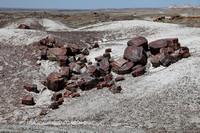 Long Log Trail
Along the trail there are a lot of broken pieces of petrified wood. Some has diameter over a few feet. There are some trunks 30 to 50 feet long broken off into 2-3 feet each section. Some are half buried in the sand. We can see the petrified woods were originally buried under the sand. The national park website said that millions of years ago the forest was flooded under water. The water penetrated deep into the wood. Over time sedimentary soil covered the trees. As the wood got buried deep down, the pressure turned the wood into colorful fossils after a few million years. The earth later rose and the soft sedimentary rocks eroded by wind and rain. And now the tree fossils are exposed. Many of them are the straight long tree trunks. We can still see the textures of the tree barks. We can see colorful bands in the cross sections. After polishing, the surface is very smooth. The colors are red, yellow, purple, gray and black. Some people call this rainbow rock or rainbow fossil. The man at the gift shop claims that these fossils can only be found in this region. The hardness of these fossils is similar to marble.
Agate House
We walked along the trail to Agate House. This is a small house built using sections of petrified wood. It is about the size of a single room, one story high. Next to it another small building is half collapsed. They look like a mix between a log cabin and a stone cabin.
From the Agate House we continue on the loop road back to the parking lot. This is already quite far and not many people are here. We saw a lot of small pieces of petrified wood everywhere. You might wonder why I bought from the gift shop and not just pick some from the ground. Because it is prohibited to remove any fossils or other artifacts from the park.
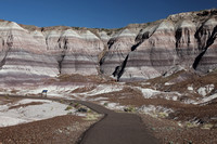 Blue Mesa
After we got back to the car, we move onto the next viewpoint. We skipped one that is not too impressive. We went to Blue Mesa that the ranger suggested. From the trailhead we can see badlands. We walked down a paved trail into a series of sand dune looking mesa. The most amazing thing is that the hills has horizontal color bands. The color bands are sediments of various soil types. At various points in time different soil composition are deposited on this region. We are curious and touched the dunes. It is hard like rock and yet very loose and soft and crumpled under our touch. I once heard a tour guide describe this as "to-fu" hills. I think is quite to-the-point. I like this place a lot. We then go to a small pueblo ruin and a small indian rock art pile. Too bad the rock arts are too far from the fenced overlook and we can't really see much.
Route 66 Landmark
Before we reached the north exit, there is a landmark for Route-66. Once upon a time Route 66 was the rich culture of the America West. But since the Interstate highway was built, Route 66 was mostly abandoned.
Getting Lost Heading To Chinle
It is now nearly 4pm. We still have to drive 2 hours to the hotel. There are no towns here to stay overnight. This is the real nowhere land. From Petrified Forest to Chinle, Canyon de Chelly is about 2 hours, take I-40 East to US-191 North. US-191 was broken in the middle connected by a short distance on Route 264 West. But we followed the GPS and took Route 264 East and went on to a road that runs parallel to US-191. The first half of the road was ok but the second half isn't ok. When there were only about 20 miles left the road turned into a dirt road. Very bumpy. We had to go slow. We spent over half hour over the dirt road. We couldn't turn back because there were no other intersections in last 1 hour. The sky is getting dark now. If it is dark, it is even harder to find the road. We are now on Navajo land in the Indian nation. There are no house or any one anywhere. We couldn't even ask directions. The cell phone has no signal. We can only blindly trust the GPS and continue to drive on the current road. Finally we emerged onto a small town and saw the US-191 not far from where we are. Thank god, we arrived in the right place and found the hotel. We asked the reception at the hotel about the road. They said they knew some GPS points to the wrong road that has the dirt road section but would till got us there. I thought there are only a few roads here and is not easy to get lost so I didn't print the detail turn-by-turn map. Almost got lost here. Once we settled down we ate at the restaurant in the hotel. Today's special is cowboy steak. Since we did not have a proper lunch, we were particularly hungry.
***Chinese Version below***
Getting There
第二日由Flagstaff上州際公路I-40 向東走兩2小時,到Petrified Forest National Park木化石國家公園. 由此開始進入荒漠地帶,這個地方有兩個入口,南北各一,
Gift Shop
一見七彩晶瑩的木化石製品我就左揀右揀,
Visitor Center
第一站訪客處,遇上一輛旅遊巴士,所以有不少人在,
Long Log Trail
小徑四週都有散落的木化石,有的直徑超過幾尺,比人合抱還大,
沿著小徑一直走到Agate House, 在茫茫曠野有一間小房子,長濶約十多尺,只有一層高,旁邊還有半間倒塌了的,
Blue Mesa
取回車子沿途到下一個景點,看一下沒有甚麼特別,爭取時間再到下一個,
Route 66 Landmark
最後到達北邊出口之前有個紀念66公路的路標,
| Back to Day 1-Sedona | Day 2-Petrified Forest |
Next to Day 3-Canyon De Chelly and Monument Valley |
]]>
What is Grand Circle
This trip has a name, Grand Circle, meaning an area covering Arizona, Utah, and Colorado, that has the most concentration of national parks that showcase geological wonders of the earth. The most famous national park here is Grand Canyon. This time I spent two weeks in 8 national parks and 3 Indian Reserves.
Getting There
From Phoenix head north on I-17 to Sedona. Sedona is a resort town. Reddish sandstone buttes surround the town. New Age believers say there are energy vortex here that can boost your energy. Many resorts and spas can be found here. There are many art galleries. This is also a popular place for retirees.
Montezuma Castle
Before we arrive at Sedona, we stopped by the Montezuma Castle National Monument. A small ruin situated in the middle of a vertical cliff. Tucked into the cliff about a hundred feet above the valley floor. The cave dwelling was built about 800 years ago. It was abandoned for hundreds of years. Several years ago people are still allowed to go up to the ruin. But due to eroded trail and vandalism, they don't allow people to go up there any more. Most people who come here are passionate about nature, environmentally friendly, and observe the carry in carry out rule for national parks.
National Park Annual Pass and National Park Passport
At the park entrance we bought the annual pass for $80. Good for one passenger car unlimited entry to all national parks for a year. It can be used by two people. This is much cheaper than paying separate entry fees. We also bought a national park passport as souvenir for $10. We can get it stamped at every national park visitor center.
Sedona
At Sedona we went to a Mexican restaurant Xcara for lunch. Back in 2004 we were at the same restaurant. From the second floor balcony seats, we can see the red rock mountains in a distance. This is a wonderful place to start our journey. We ordered hamburger and shrimp salad tacos. This is still a big town so there is still some seafood even though we are already in the desert area. From here on further into the remote desert wilderness, there won't be much seafood.
Protect Yourself in Hot Dry Desert Weather
The weather here is very dry. We need to drink a lot of water, use the strongest sun block lotion. In big cities there are heavy air pollution, the sky is always dull gray. But here, the sky is clear and blue. You can see as far as the horizon. Even the UV rays that bound off the desert sand is still very strong. If you don't use sun-block lotion for a few hours, your skin would get sun-burn. Although it is hot, but not humid. This is still spring, so the weather is around 70-80F during the day.
Red Rock State Park Loop Road
Once we fed ourselves, we drove up the Red Rock State Park Loop Road. There are no prominent signs, only a few pullout viewpoints for taking photos. On one of the larger pullout, we can see the town below us surrounded by red rock sandstone buttes.
Airport Mesa Road
Further up we go onto the Airport Mesa Road. There is a parking lot on top of the hill. This is where a small airport is located. There are some coin operated telescopes from which we can view Sedona and the mountains around us. The sun is now setting low. We still have a short drive to the hotel tonight. On the way we need to pass a treacherous hairpin mountain roadway, like those in Initial D. So it is best we get there before dark. Tomorrow we also have a long journey to go, so we head towards our hotel at Flagstaff.
***Chinese Version***
What is Grand Circle
這個旅程有個名字,Grand Circle,意思是美國西南方三個州,亞利桑那州,猶他州,科羅拉多州,集中了最多的國家公園,最奇特的地貌,當中最有名的就是大峽谷,今㳄兩星期我去了八個國家公園,兩個印第安人保護區,非常充實。
Getting There
從Phoenix出發向北,上州際公路I-17 North,兩小時後第一站Sedona,一個休閒鎮,四週有紅石山,風景如畫,山谷之中傳說有某些地方可增強人的能量,New Age人士愛到這裏度假,有不少resort, spa, 有賣藝術品的店,亦有部分人來退休長住。
Montezuma Castle
到鎮上之前順路有個小景點,Montezuma Castle National Monument, 山崖之上在直上直下的峭壁約百尺高有個山洞,山洞之中有八百年前土人所建築的石居,早已廢棄,聽說好幾年之前還可走上去,不過現在鈄路危險,公園為了防止遊人破壞,已經不准人上去,到這些地方遊覧的人多數熱愛大自然,支持環保,所以破壞者不多,但長年累月要保全依然很難,還要依賴訪客自律。
National Park Annual Pass and National Park Passport
在這個訪客中心買了國家公園Annual Pass門票,一年內任用,可二人共用,盛惠八十美元,比每個公園分開買票每次二十平得多,再買一個紀念冊national park passport可以在每個國家公園的訪客站蓋上印章,紀念冊只需十美元。
Red Rock State Park Loop Road
吃飽了正式去玩,駛上Red Rock State Park Loop Road, 這𥚃沒有什麼正式路牌指標,有幾個地方可以停下拍照,這條路在小山上,可以望見小鎮在山谷中被紅石山圍繞,
Airport Mesa Road
再走高些上Airport Mesa Road, 上面有個停車塲有幾個入硬幣望遠鏡可遠眺山景,這時太陽開始西斜,還有一段路才到今晚酒店,要經過一段很㞳峭的髮夾彎道,好似頭文字那種,最好天黑之前越過那段路,而且明天車程很長,早點回酒店睡吧。
| Back to Travelog | Day 1-Sedona | Next to Day 2-Petrified Forest |
]]>
Week One Huangshan
香港![]() 杭州
杭州![]() 黃山 (世界自然與文化雙遺產)
黃山 (世界自然與文化雙遺產)
~ 黃山:黃山的美景,自古以來就被李白、杜甫等詩人所稱頌。五嶽歸來不看山、黃山歸來不看嶽,可見黃山之地位。~杭州至黃山,車程約3小時。
屯溪![]() 黃山
黃山![]() 世界文化遺產:宏村 (承志堂、南湖書院及敬休堂)
世界文化遺產:宏村 (承志堂、南湖書院及敬休堂)![]() 玉屏纜車站 (安排乘纜車前山上山)
玉屏纜車站 (安排乘纜車前山上山)![]() 前山玉屏樓
前山玉屏樓![]() 迎客松
迎客松![]() 百步雲梯
百步雲梯![]() 蓮花梗
蓮花梗![]() 遠眺天都峰
遠眺天都峰![]() 螯魚峰
螯魚峰![]() 海心亭
海心亭![]() 白雲景區
白雲景區
黃山黎明時份觀日出![]() 西海黃山風景區 (西海大峽谷~)(排雲亭、仙人曬靴、魔幻景區、遠眺丹霞峰、遠眺飛來石、光明頂等)
西海黃山風景區 (西海大峽谷~)(排雲亭、仙人曬靴、魔幻景區、遠眺丹霞峰、遠眺飛來石、光明頂等)![]() 北海黃山風景區
北海黃山風景區![]() 始信峰 (可觀黃山奇松如:連理松、豎琴松、探海松等)
始信峰 (可觀黃山奇松如:連理松、豎琴松、探海松等)![]() 獅子峰
獅子峰![]() 猴子觀海景區
猴子觀海景區![]() 觀日落
觀日落
*全日遊覽西海及北海風景區約需步行10小時
雲谷纜車站後山下山![]() 宋代老街
宋代老街![]() 黃山世紀廣場
黃山世紀廣場![]() 屯溪
屯溪![]() 杭州
杭州
~黃山至杭州,車程約3小時。
杭州![]() 「西湖新天地」風景區
「西湖新天地」風景區![]() 漫步「法國建築、香榭麗榭大道、杭州步行街」
漫步「法國建築、香榭麗榭大道、杭州步行街」![]() 香港
香港
宏村位於黃山腳下的古村落,古時為汪氏一族的聚居地,村內的水道跟據風水而建,戶戶相連,極具特色。參觀宏村最漂亮的承志堂,整幢宅院以磚木結構為主,內裡的雕刻裝飾更是巧奪天工。再到位於南湖畔的南湖書院,於清朝時期將依湖的六院合併重建而成,頗為壯觀。遊覽為汪氏宗祠之樂敘堂,建於15世紀初,前門仍然保留著原貌,具有典型的明代風格,建築構件雕刻精美。
黃山之前後山各住宿1晚,以多角度細緻遊覽人間美景,感受大自然的鬼斧神工。
乘坐纜車於前山上山,後山下山,順序暢遊,飽覽西海及北海風景區,觀賞著名景點如迎客松、飛來石、光明頂、連理松等。
Week Two Zhang Jia Jie
香港![]() 長沙
長沙![]() 天心閣 (十大歷史文化名樓之一)
天心閣 (十大歷史文化名樓之一)
長沙![]() 吉首
吉首![]() 鳳凰古城(包門票)參觀楊家祠堂、沈從文故居、吊腳樓、東門城樓、虹橋藝術樓、石板街、萬名塔、北門城樓、跳岩
鳳凰古城(包門票)參觀楊家祠堂、沈從文故居、吊腳樓、東門城樓、虹橋藝術樓、石板街、萬名塔、北門城樓、跳岩![]() 特別安排前往古城夜遊
特別安排前往古城夜遊
鳳凰古城![]() 永順
永順![]() 芙蓉鎮
芙蓉鎮![]() 王村大瀑布
王村大瀑布![]() 貞節牌坊
貞節牌坊![]() 113號米豆腐店
113號米豆腐店![]() 張家界
張家界![]() 天門山國家森林公園 (包乘坐來回索道)
天門山國家森林公園 (包乘坐來回索道)![]() (俯瞰九十九彎的通天大道)
(俯瞰九十九彎的通天大道)![]() (雲夢仙頂、凌霄台、鬼谷棧道、天門洞(遠眺)~世界最高海拔天然穿山溶洞)
(雲夢仙頂、凌霄台、鬼谷棧道、天門洞(遠眺)~世界最高海拔天然穿山溶洞)![]() 軍聲畫院
軍聲畫院
天門洞:世界最高海拔天然穿山溶洞,懸於海拔1300多米的峭壁之上,高131.5米,寬57米,深60米,終年吐雲納霧。
武陵源![]() 袁家界 (包乘坐環保車、百龍電梯)(天下第一橋、迷魂台後花園)
袁家界 (包乘坐環保車、百龍電梯)(天下第一橋、迷魂台後花園)![]() 天子山風景區 (包乘坐纜車)( 賀龍公園、西海、御筆峰、仙女散花、神堂灣、雲星岩觀景台)
天子山風景區 (包乘坐纜車)( 賀龍公園、西海、御筆峰、仙女散花、神堂灣、雲星岩觀景台)![]() 十里畫廊 (包乘坐雙程小火車暢遊)
十里畫廊 (包乘坐雙程小火車暢遊)
張家界![]() 世界地質公園
世界地質公園![]() 金鞭溪
金鞭溪![]() 金鞭岩
金鞭岩![]() 神鷹護鞭
神鷹護鞭![]() 長沙
長沙
長沙![]() 嶽麓山
嶽麓山![]() 嶽麓書院 (包來回環保車)
嶽麓書院 (包來回環保車)![]() 長沙
長沙![]() 香港
香港
天門山國家森林公園
乘坐世界最長的高山索道,體驗凌空飛仙般的神奇感覺
.天門山最高海拔1518.6米,為張家界最高峰,因其臨空獨尊的氣勢,被尊稱為張家界之魂,也是張家界最早載入史冊的名山,1992年被定為國家森林公園。特別安排乘坐世界最長的高山索道由張家界市中心直達天門山。
張家界國家森林公園
天子山風景區(包環保車、纜車上山、百龍電梯下山)、十里畫廊(包乘小火車)
‧武陵源,由張家界國家公園、天子山、索溪山谷三大風景區組,於1992年被定為《世界自然遺產》。
.乘坐亞洲唯一建於山體懸崖旳觀光電梯“百龍電梯”。
.前往張家界天下第一橋,橫跨兩座山頭,而橋旁為萬丈深溝,無數英砂岩石峰奇形各異。
暢遊真實的「潘多拉」世界
‧ 前往「阿凡達—哈利路亞山」(又名「南天一柱」),欣賞《阿凡達》片中懸浮山的原型。
.「潘多拉星球」取景點,如袁家界的迷魂台、金鞭溪的劈山救母、天子山的禦筆峰等,帶你進入「潘多拉」世界。
中國最美古城之一「鳳凰古城」
.鳳凰古城是國家歷史文化名城。遊覽古城,參觀楊家祠堂、沈從文故居、吊腳樓、東門城樓、虹橋藝術樓、石板街、萬名塔、北門城樓、跳岩。住宿古城1晚,晚餐後前往古城夜遊。
(Source from my travel agent trip itinerary)
]]>
Although sheer number isn't everything, I still feel a rush of excitement when I realized I have chosen to share over one thousand photos here.
Most pictures are national park landscape photos. A few galleries are China travel photos. Some more from other US locations.
I still have a lot of pictures from Europe that I am still picking and choosing before posting them here.
I am also working on adding more blogs. So check back often. Soon you will see more.
]]>Video was created with photos taken across the entire season of 2011.
End of December 2010 a big snow storm dumped two feet of snow in my backyard.
When spring came, I decided to document how the garden shape up over the season.
Roughly by month, the flowers in bloom are:
April - Forsythia, Daffodils, Hyacinths, Azalea (purple gem)
May - Bleeding Hearts, May Salvia, Gerber Daisies, Azalea (red and white and pink), German Bearded Iris, Lily-of-the-valley, Peonies,
June - Roses, Carnations, Daylily Stella D'Oro, Cala Lily (purple), Hydrangea, Hosta, Dusty Miller, Lavender
July - Oriental Lily, Cala Lily (yellow), Daylily (red), Black Eyed Susan, Roses
August - Chrysanthymum, Wonder of Staffa, Clementis, Russian Sage, Roses
After the snow in early April I transplanted a Japanese Maple tree in the left corner.
A lot of the flowers were moved around in March and April. By early summer the garden was shaping up nicely.
In contrast the winter for 2011/12 is rather mild. I did very little in 2012 in the garden.
I am glad it is grown into the low maintenance garden I had hoped for.
]]>